Guatemala Volcanoes
-
Fuego
-
Pacaya
-
Chingo
-

Suchitan
-
Tecuamburro
-
Pacaya
-

Pacaya
-
Fuego
-
Fuego
-

Acatenango
-
Santa Maria
-

Tacana
-
Flores
-

Santa Maria
-
Almolonga
-
Pacaya
-

Atitlan
-
Santa Maria
-
Pacaya
-

Suchitan
Guatemala has 21 Holocene volcanoes. Note that as a scientific organization we provide these listings for informational purposes only, with no international legal or policy implications. Volcanoes will be included on this list if they are within the boundaries of a country, on a shared boundary or area, in a remote territory, or within a maritime Exclusive Economic Zone. Bolded volcanoes have erupted within the past 20 years. Suggestions and data updates are always welcome ().
| Volcano Name | Location | Last Eruption | Primary Volcano Type |
|---|---|---|---|
| Acatenango | South-Central Guatemala | 1972 CE | Stratovolcano(es) |
| Agua | South-Central Guatemala | Unknown - Evidence Credible | Stratovolcano |
| Almolonga | Southwestern Guatemala | 1818 CE | Stratovolcano |
| Atitlan | South-Central Guatemala | 1853 CE | Stratovolcano(es) |
| Chingo | Southeastern Guatemala | Unknown - Evidence Credible | Stratovolcano |
| Cuilapa-Barbarena | Guatemala | Unknown - Evidence Credible | Volcanic field |
| Flores | Southeastern Guatemala | Unknown - Evidence Credible | Volcanic field |
| Fuego | South-Central Guatemala | 2024 CE | Stratovolcano(es) |
| Ixtepeque | Southeastern Guatemala | Unknown - Evidence Credible | Lava dome(s) |
| Jumaytepeque | Guatemala | Unknown - Evidence Uncertain | Stratovolcano |
| Moyuta | Southeastern Guatemala | Unknown - Evidence Credible | Stratovolcano |
| Pacaya | South-Central Guatemala | 2021 CE | Complex |
| San Diego | Western El Salvador | Unknown - Evidence Credible | Volcanic field |
| Santa Maria | Southwestern Guatemala | 2024 CE | Stratovolcano |
| Cerro Santiago | Southeastern Guatemala | Unknown - Evidence Credible | Volcanic field |
| Suchitan | Southeastern Guatemala | Unknown - Evidence Credible | Stratovolcano(es) |
| Tacana | México-Guatemala border | 1986 CE | Stratovolcano |
| Tahual | Southeastern Guatemala | Unknown - Evidence Credible | Stratovolcano |
| Tajumulco | Southwestern Guatemala | Unknown - Evidence Credible | Stratovolcano |
| Tecuamburro | South-Central Guatemala | 960 BCE | Stratovolcano |
| Toliman | South-Central Guatemala | Unknown - Evidence Credible | Stratovolcano(es) |
Chronological listing of known Holocene eruptions (confirmed or uncertain) from volcanoes in Guatemala. Bolded eruptions indicate continuing activity.
| Volcano Name | Start Date | Stop Date | Certainty | VEI | Evidence |
|---|---|---|---|---|---|
| Pacaya | 2015 Jun 7 ± 1 days | 2021 Aug 13 | Confirmed | 1 | Observations: Reported |
| Pacaya | 2014 Aug 25 | 2015 Feb 17 | Confirmed | 1 | Observations: Reported |
| Pacaya | 2013 Mar 5 | 2014 Apr 10 | Confirmed | 2 | Observations: Reported |
| Pacaya | 2006 Mar 9 | 2010 Oct 26 | Confirmed | 3 | Observations: Reported |
| Pacaya | 2004 Jul 19 (?) | 2005 Sep 11 | Confirmed | 1 | Observations: Reported |
| Pacaya | 2002 May 30 | 2002 Jun 17 (?) | Confirmed | 1 | Observations: Reported |
| Fuego | 2002 Jan 4 | 2024 Apr 19 (continuing) | Confirmed | 2 | Observations: Reported |
| Pacaya | 2001 Oct 31 | 2001 Oct 31 | Confirmed | 1 | Observations: Reported |
| Pacaya | 2000 Aug 16 ± 15 days | 2001 Jul 5 (?) | Confirmed | 1 | Observations: Reported |
| Fuego | 1999 May 21 | 2000 Dec 9 (in or after) | Confirmed | 2 | Observations: Reported |
| Pacaya | 1990 Jan 4 (?) | 2000 Mar 1 | Confirmed | 3 | Observations: Reported |
| Fuego | 1987 Jan 5 ± 4 days | 1987 Feb 16 (?) ± 15 days | Confirmed | 1 | Observations: Reported |
| Tacana | 1986 Feb 16 ± 15 days | 1986 Jun 16 ± 15 days | Confirmed | 1 | Observations: Reported |
| Fuego | 1977 Sep 11 | 1979 Aug 8 | Confirmed | 2 | Observations: Reported |
| Fuego | 1977 Mar 3 | 1977 Apr 19 | Confirmed | 1 | Observations: Reported |
| Fuego | 1975 May 28 | 1975 Oct 21 | Confirmed | 1 | Observations: Reported |
| Fuego | 1974 Oct 10 | 1974 Dec 4 | Confirmed | 4 | Observations: Reported |
| Fuego | 1973 Feb 23 | 1973 Mar 23 | Confirmed | 2 | Observations: Reported |
| Acatenango | 1972 Nov 12 | 1972 Dec 16 ± 15 days | Confirmed | 1 | Observations: Reported |
| Fuego | 1971 Sep 14 | 1971 Sep 15 | Confirmed | 3 | Observations: Reported |
| Fuego | 1967 Apr 22 | 1967 Apr 24 | Confirmed | 2 | Observations: Reported |
| Fuego | 1966 Aug 12 | 1966 Aug 13 | Confirmed | 3 | Observations: Reported |
| Fuego | 1966 Feb 7 | 1966 May 1 | Confirmed | 3 | Observations: Reported |
| Pacaya | 1965 Jul 4 | 1989 Mar 10 | Confirmed | 3 | Observations: Reported |
| Fuego | 1963 Sep 28 | 1963 Sep 30 | Confirmed | 3 | Observations: Reported |
| Fuego | 1962 Aug 4 | 1962 Nov 9 | Confirmed | 3 | Observations: Reported |
| Pacaya | 1961 Mar 11 | 1961 Apr 15 (?) | Confirmed | 2 | Observations: Reported |
| Fuego | 1957 Feb 19 | 1957 Feb 21 (in or after) | Confirmed | 3 | Observations: Reported |
| Fuego | 1955 Jul 26 ± 5 days | Unknown | Confirmed | 1 | Observations: Reported |
| Fuego | 1953 Apr 9 | 1953 Apr 13 | Confirmed | 3 | Observations: Reported |
| Tacana | 1949 Dec 22 | 1950 Jan 16 ± 15 days | Confirmed | 1 | Observations: Reported |
| Fuego | 1949 Nov | Unknown | Confirmed | 2 | Observations: Reported |
| Fuego | 1947 | Unknown | Confirmed | 2 | Observations: Reported |
| Fuego | 1944 Dec 1 ± 30 days | Unknown | Confirmed | 2 | Observations: Reported |
| Fuego | 1932 Jan 21 | 1932 Jan 22 | Confirmed | 4 | Observations: Reported |
| Acatenango | 1926 Aug | 1927 May 19 | Confirmed | 2 | Observations: Reported |
| Acatenango | 1924 Dec 18 | 1925 Jun 7 | Confirmed | 3 | Observations: Reported |
| Santa Maria | 1922 Jun 22 | 2024 Apr 19 (continuing) | Confirmed | 3 | Observations: Reported |
| Santa Maria | 1903 | 1913 | Confirmed | 2 | Observations: Reported |
| Santa Maria | 1902 Oct 24 | 1902 Nov 12 | Confirmed | 6 | Observations: Reported |
| Fuego | 1896 Jan 10 | Unknown | Confirmed | 2 | Observations: Reported |
| Pacaya | 1885 Dec | Unknown | Confirmed | 2 | Observations: Reported |
| Fuego | 1880 Jun 28 | 1880 Aug 20 | Confirmed | 4 | Observations: Reported |
| Tacana | 1878 | Unknown | Confirmed | 1 | Observations: Reported |
| Fuego | [1867] | [Unknown] | Uncertain | ||
| Tajumulco | [1863] | [Unknown] | Uncertain | ||
| Fuego | [1861 Nov 21] | [Unknown] | Uncertain | ||
| Fuego | 1860 Aug 18 | 1860 Sep 23 | Confirmed | 2 | Observations: Reported |
| Fuego | 1857 Sep 17 | Unknown | Confirmed | 2 | Observations: Reported |
| Fuego | 1857 Jan 15 | 1857 Feb 17 | Confirmed | 4 | Observations: Reported |
| Fuego | 1856 Sep 29 | 1856 Sep 30 | Confirmed | 2 | Observations: Reported |
| Fuego | 1856 Jan 9 | 1856 Mar 7 | Confirmed | 2 | Observations: Reported |
| Atitlan | [1856] | [Unknown] | Uncertain | ||
| Fuego | 1855 Sep 29 | 1855 Sep 30 | Confirmed | 2 | Observations: Reported |
| Tacana | [1855 Jan 12] | [Unknown] | Uncertain | ||
| Atitlan | 1853 May 3 | Unknown | Confirmed | 3 | Observations: Reported |
| Atitlan | [1852] | [Unknown] | Uncertain | ||
| Fuego | [1852] | [Unknown] | Uncertain | ||
| Fuego | [1850] | [Unknown] | Uncertain | ||
| Pacaya | 1846 Feb | Unknown | Confirmed | 2 | Observations: Reported |
| Atitlan | 1843 Jul | Unknown | Confirmed | 2 | Observations: Reported |
| Atitlan | 1837 Jun | Unknown | Confirmed | 2 | Observations: Reported |
| Atitlan | 1833 | Unknown | Confirmed | 2 | Observations: Reported |
| Pacaya | [1830] | [Unknown] | Uncertain | ||
| Fuego | 1829 | Unknown | Confirmed | 2 | Observations: Reported |
| Atitlan | 1827 Sep 1 | 1828 Jan (?) | Confirmed | 3 | Observations: Reported |
| Atitlan | 1827 Mar 27 | Unknown | Confirmed | 2 | Observations: Reported |
| Atitlan | 1826 Nov | Unknown | Confirmed | 2 | Observations: Reported |
| Fuego | 1826 | Unknown | Confirmed | 2 | Observations: Reported |
| Tajumulco | [1821] | [Unknown] | Uncertain | ||
| Almolonga | 1818 Jan 16 | 1818 Jun 19 (in or after) | Confirmed | 2 | Observations: Reported |
| Pacaya | 1805 | Unknown | Confirmed | 2 | Observations: Reported |
| Fuego | 1799 | Unknown | Confirmed | 3 | Observations: Reported |
| Pacaya | 1775 Jul 1 | 1775 Jul 23 (in or after) | Confirmed | 3 | Observations: Reported |
| Fuego | [1773] | [Unknown] | Uncertain | ||
| Almolonga | 1765 Oct 24 | 1765 Oct 25 | Confirmed | 2 | Observations: Reported |
| Fuego | [1765] | [Unknown] | Uncertain | ||
| Pacaya | [1760] | [Unknown] | Uncertain | ||
| Fuego | [1751] | [Unknown] | Uncertain | ||
| Fuego | 1737 Aug 27 | 1737 Sep 24 | Confirmed | 4 | Observations: Reported |
| Fuego | 1732 May | Unknown | Confirmed | 2 | Observations: Reported |
| Fuego | 1730 Sep | Unknown | Confirmed | 2 | Observations: Reported |
| Atitlan | 1717 Aug 29 | 1721 | Confirmed | Unknown | |
| Fuego | 1717 Aug 27 | 1717 Dec 26 ± 5 days | Confirmed | 4 | Observations: Reported |
| Pacaya | [1717] | [Unknown] | Uncertain | ||
| Fuego | 1710 Oct 14 | Unknown | Confirmed | 2 | Observations: Reported |
| Fuego | [1709 Oct 14] | [Unknown] | Uncertain | ||
| Fuego | 1706 Oct 4 | Unknown | Confirmed | 2 | Observations: Reported |
| Fuego | 1705 Jan 31 | 1705 Feb 2 | Confirmed | 2 | Observations: Reported |
| Fuego | 1702 Aug 4 | Unknown | Confirmed | 2 | Observations: Reported |
| Pacaya | 1699 Jun 29 | Unknown | Confirmed | 2 | Observations: Reported |
| Fuego | 1699 | Unknown | Confirmed | 2 | Observations: Reported |
| Pacaya | 1693 | Unknown | Confirmed | 2 | Observations: Reported |
| Pacaya | 1690 | Unknown | Confirmed | 2 | Observations: Reported |
| Fuego | [1689] | [Unknown] | Uncertain | ||
| Pacaya | 1687 Mar 26 | 1687 Mar 27 | Confirmed | 2 | Observations: Reported |
| Fuego | 1686 | Unknown | Confirmed | 2 | Observations: Reported |
| Fuego | 1685 Sep | Unknown | Confirmed | 2 | Unknown |
| Fuego | [1679] | [Unknown] | Uncertain | ||
| Pacaya | 1678 Aug (?) | Unknown | Confirmed | 2 | Observations: Reported |
| Pacaya | [1677 Jul] | [Unknown] | Uncertain | ||
| Pacaya | 1674 Jul | Unknown | Confirmed | 2 | Observations: Reported |
| Pacaya | 1671 Aug | Unknown | Confirmed | 2 | Observations: Reported |
| Pacaya | 1668 Aug | 1669 Jun 29 | Confirmed | 2 | Observations: Reported |
| Pacaya | 1664 | Unknown | Confirmed | 3 | Observations: Reported |
| Atitlan | 1663 | Unknown | Confirmed | 2 | Observations: Reported |
| Pacaya | 1655 Jul | Unknown | Confirmed | 2 | Observations: Reported |
| Pacaya | 1651 Feb 18 | 1651 Apr 13 | Confirmed | 2 | Observations: Reported |
| Fuego | 1629 | 1632 | Confirmed | 2 | Observations: Reported |
| Fuego | 1623 Jan | Unknown | Confirmed | 2 | Observations: Reported |
| Pacaya | 1623 (?) | Unknown | Confirmed | 3 | Observations: Reported |
| Fuego | 1620 | Unknown | Confirmed | 2 | Observations: Reported |
| Fuego | 1617 | Unknown | Confirmed | 3 | Observations: Reported |
| Fuego | 1614 | Unknown | Confirmed | 2 | Observations: Reported |
| Fuego | 1587 Jul 24 | Unknown | Confirmed | 2 | Observations: Reported |
| Fuego | 1586 Jun 3 ± 2 days | 1586 Dec | Confirmed | 2 | Observations: Reported |
| Fuego | 1585 Jan 15 | 1585 Jul | Confirmed | 2 | Observations: Reported |
| Fuego | 1581 Dec 5 | 1582 Jan 15 | Confirmed | 4 | Observations: Reported |
| Atitlan | 1579 (?) | 1581 Dec 31 ± 30 days | Confirmed | 2 | Observations: Reported |
| Fuego | [1577] | [Unknown] | Uncertain | ||
| Fuego | [1576] | [Unknown] | Uncertain | ||
| Fuego | [1575] | [Unknown] | Uncertain | ||
| Fuego | [1571 Dec 25] | [Unknown] | Uncertain | ||
| Pacaya | 1565 Aug (?) | Unknown | Confirmed | 3 | Observations: Reported |
| Fuego | [1565] | [Unknown] | Uncertain | ||
| Fuego | [1559 Jan 16] | [Unknown] | Uncertain | ||
| Fuego | [1557 Jan 15] | [Unknown] | Uncertain | ||
| Fuego | 1551 | 1552 Mar 31 (in or after) | Confirmed | 2 | Observations: Reported |
| Fuego | 1542 Jan 14 | Unknown | Confirmed | Observations: Reported | |
| Fuego | 1541 | Unknown | Confirmed | Unknown | |
| Fuego | 1531 Dec 31 ± 30 days | Unknown | Confirmed | 2 | Observations: Reported |
| Fuego | [1526] | [Unknown] | Uncertain | ||
| Fuego | 1524 Apr 30 ± 30 days | 1524 Jul 15 ± 45 days | Confirmed | 2 | Observations: Reported |
| Atitlan | 1505 (?) | Unknown | Confirmed | 3 | Observations: Reported |
| Atitlan | 1469 | Unknown | Confirmed | 3 | Observations: Reported |
| Suchitan | [1469] | [Unknown] | Uncertain | ||
| Acatenango | 1450 ± 50 years | Unknown | Confirmed | Correlation: Anthropology | |
| Pacaya | 1360 ± 75 years | Unknown | Confirmed | 3 | Isotopic: 14C (uncalibrated) |
| Pacaya | 1160 ± 75 years | Unknown | Confirmed | 3 | Isotopic: 14C (uncalibrated) |
| Tacana | 1030 ± 40 years | Unknown | Confirmed | Isotopic: 14C (uncalibrated) | |
| Fuego | 0970 ± 50 years | Unknown | Confirmed | Isotopic: 14C (uncalibrated) | |
| Fuego | 0900 ± 75 years | Unknown | Confirmed | Isotopic: 14C (uncalibrated) | |
| Pacaya | 0880 ± 500 years | Unknown | Confirmed | 3 | Correlation: Tephrochronology |
| Almolonga | 0800 ± 50 years | Unknown | Confirmed | 3 | Isotopic: 14C (calibrated) |
| Fuego | 0590 ± 75 years | Unknown | Confirmed | Isotopic: 14C (uncalibrated) | |
| Pacaya | 0400 ± 50 years | Unknown | Confirmed | 2 | Isotopic: 14C (uncalibrated) |
| Acatenango | 0090 ± 100 years | Unknown | Confirmed | Isotopic: 14C (uncalibrated) | |
| Tacana | 0070 ± 100 years | Unknown | Confirmed | 4 | Isotopic: 14C (calibrated) |
| Acatenango | 0260 BCE ± 75 years | Unknown | Confirmed | Isotopic: 14C (uncalibrated) | |
| Acatenango | 0370 BCE ± 200 years | Unknown | Confirmed | Isotopic: 14C (uncalibrated) | |
| Tecuamburro | 0960 BCE ± 75 years | Unknown | Confirmed | Isotopic: 14C (uncalibrated) | |
| Atitlan | 1020 BCE ± 150 years | Unknown | Confirmed | Isotopic: 14C (uncalibrated) | |
| Tacana | 1080 BCE ± 150 years | Unknown | Confirmed | Isotopic: 14C (calibrated) | |
| Fuego | 1580 BCE ± 75 years | Unknown | Confirmed | Isotopic: 14C (uncalibrated) | |
| Acatenango | 2710 BCE ± 75 years | Unknown | Confirmed | Isotopic: 14C (uncalibrated) | |
| Tacana | 4740 BCE ± 200 years | Unknown | Confirmed | Isotopic: 14C (calibrated) | |
| Tacana | 5720 BCE ± 200 years | Unknown | Confirmed | Isotopic: 14C (calibrated) | |
| Tacana | 5940 BCE ± 500 years | Unknown | Confirmed | Isotopic: 14C (uncalibrated) | |
| Tacana | 9450 BCE ± 150 years | Unknown | Confirmed | Isotopic: 14C (calibrated) |
Guatemala has 16 Pleistocene volcanoes. Note that as a scientific organization we provide these listings for informational purposes only, with no international legal or policy implications. Volcanoes will be included on this list if they are within the boundaries of a country, on a shared boundary or area, in a remote territory, or within a maritime Exclusive Economic Zone. Suggestions and data updates are always welcome ().
| Volcano Name | Location | Primary Volcano Type |
|---|---|---|
| Cerro Alutate | Guatemala | Stratovolcano |
| Cerro Ananopa | Guatemala | Volcanic field |
| Ayarza | Guatemala | Caldera(s) |
| Barahona | Guatemala | Caldera(s) |
| Chiquimula Volcanic Field | Southeastern Guatemala | Volcanic field |
| Cuxliquel | Guatemala | Lava dome(s) |
| Guistepeque Volcanic Field | Guatemala | Pyroclastic cone(s) |
| Ipala | Southeastern Guatemala | Stratovolcano |
| Ixhuatan | Guatemala | Complex |
| Jumay Volcanic Field | Guatemala | Stratovolcano |
| Piedra Grande | Guatemala | Stratovolcano(es) |
| Pueblo Nuevo Viñas | Guatemala | Stratovolcano |
| Cerro Redondo | Guatemala | Shield(s) |
| San Pedro | Guatemala | Stratovolcano |
| Santo Tomas-Zunil | Guatemala | Stratovolcano(es) |
| Siete Orejas | Guatemala | Stratovolcano |
There are 310 photos available for volcanoes in Guatemala.
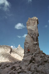 This tall feature is a collapse remnant of a lava flow extruded from the Caliente vent on the eastern side of Santiaguito lava dome between January 1972 and May 1973. A period of increased lava effusion between 1972 and 1975 was unusual because large flows originated from vents at both ends of the dome complex.
Photo by Bill Rose, 1978 (Michigan Technological University).
 The historical city of Antigua Guatemala (top-right margin) is surrounded by three major stratovolcanoes in this Landsat view with north to the upper right. Dark-colored Acatenango volcano (upper left) and the unvegetated summit of Fuego volcano lie SW of the city, and Agua volcano (right-center) lies south. No historical eruptions from Agua are known, although mudflows in 1541 caused the abandonment of Ciudad Vieja, the previous capital city of Guatemala. Barrancas radiating SE from Fuego are light-colored from deposits of historical eruptions.
 NASA Landsat image, 2000 (courtesy of Loren Siebert, University of Akron).
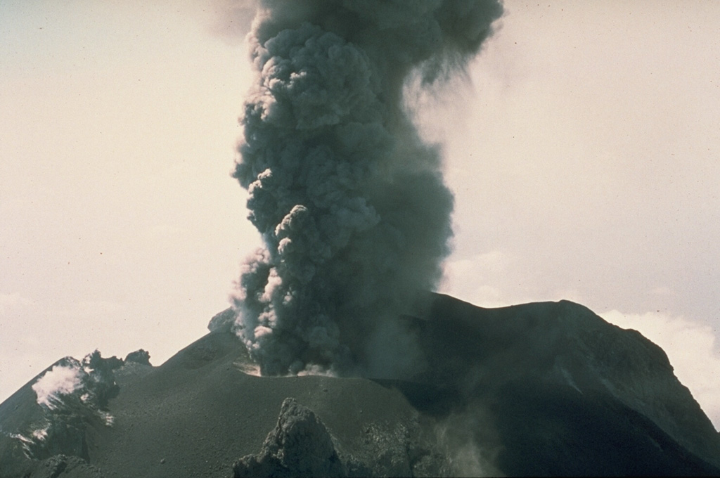
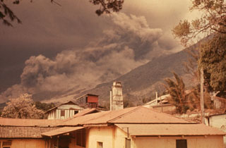 Following strong steam emission at Fuego on 22 February 1973 small eruptions beginning the next day were accompanied by pyroclastic flows down the Barranca Honda on the E flank. Explosive eruptions continued until 3 March and resumed 13 and 22-23 March. Less ash was erupted in 1973 than during the previous eruption in 1971, but pyroclastic flows were more voluminous and traveled farther downslope. This photo was taken from Finca Capetillo, near Alotenango.
Photo by Sam Bonis, 1973 (courtesy of Bill Rose, Michigan Technological University).
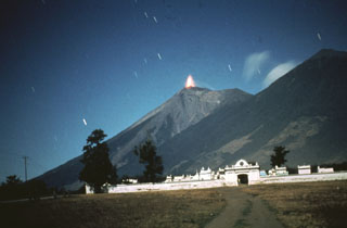
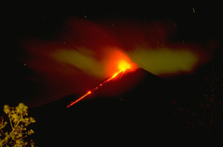 An incandescent lava flow from Pacaya is seen here moving down the SW flank with Strombolian explosions from the summit crater in November 1994.
Copyrighted photo by Stephen O'Meara, 1994.
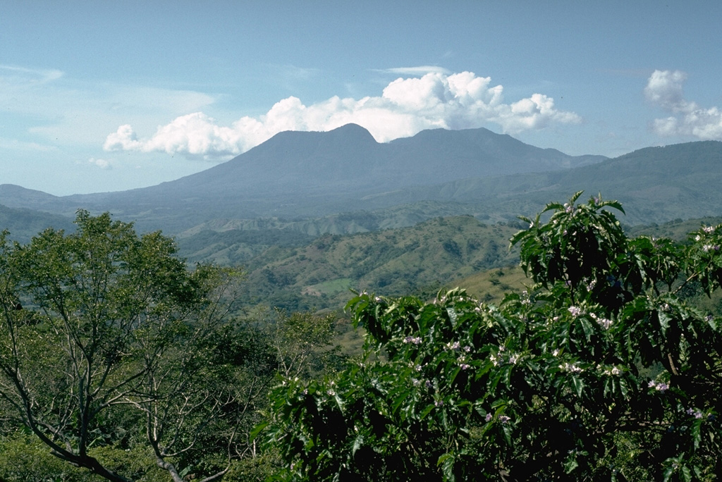
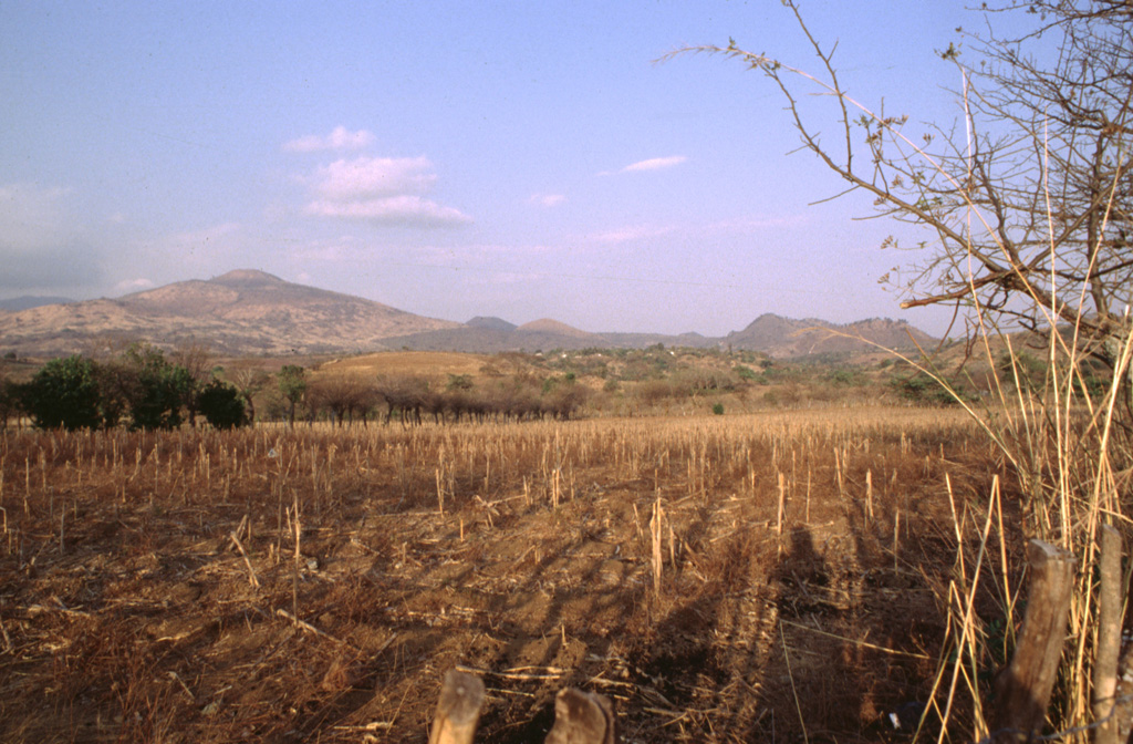
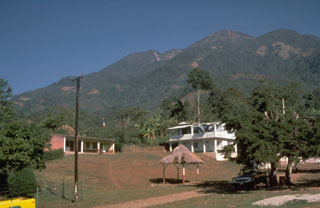
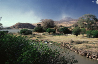
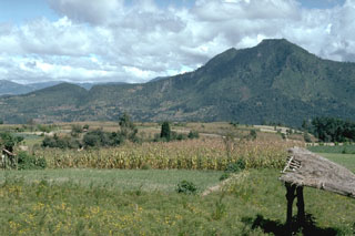
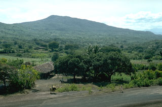
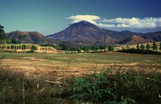
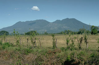
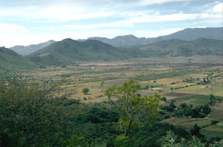
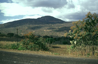
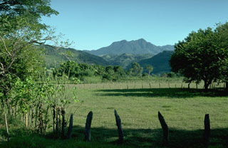 Moyuta rises above farmlands on the Pacific coastal plain of Guatemala. The forested volcano is extensively eroded and is mostly Pliocene and Pleistocene, but has a cluster of relatively young andesite to dacite lava domes at its summit. North-trending faults across the summit area form step-like ridges. Fumaroles, acid springs, and bicarbonate-rich hot springs are located on the northern and southern flanks.
Photo by Lee Siebert, 1988 (Smithsonian Institution).
 The peak to the left is San Antonio, the youngest of the Tacaná volcanic complex. A major eruption from the upper SW flank about 1,950 years ago produced a block-and-ash flow that traveled about 14 km to the south with associated lahars. The eruption concluded with the extrusion of lava flows and a lava dome. Construction at the pre-Hispanic center of Izapa was halted because of temporary abandonment of the city due to the lahars.
Photo by Norm Banks, 1987 (U.S. Geological Survey).
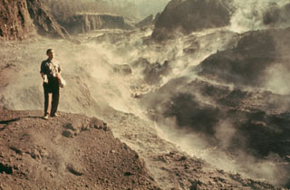
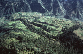
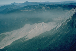
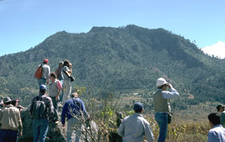 A group of volcanologists are standing on the surface of a debris avalanche deposit produced by collapse of the Cerro Quemado NE flank about 1,150 years ago, with the avalanche scarp in the background to the SW. The scarp, which fills all but the far right-hand slope of this view, is 1 x 1.5 km wide. An associated lateral blast also swept across a 40 km2 area to the NE. The eruption concluded with the emplacement of a small lava dome near the headwall of the scarp.
Photo by Lee Siebert, 1993 (Smithsonian Institution).
 The Acatenango-Fuego complex is seen here from the NW. A gas plume drifts from the summit of Fuego (right), beyond Acatenango (center). Like other N-S-trending volcanic chains in the Guatemalan highlands, activity at the Acatenango-Fuego chain migrated to the south. Yepocapa, the northernmost summit of Acatenango, was active from about 70,000 to 20,000 years ago, after which Acatenango's northern Pico Mayor was constructed. The frequently active Fuego volcano formed during the Holocene.
Photo by Lee Siebert, 1988 (Smithsonian Institution).
 A time exposure taken in 1978 from the NE shows incandescent lava ejected at the summit of Fuego. Intermittent minor eruptions took place from 11 September 1977 to 8 August 1979, sometimes producing pyroclastic flows and lava flows.
Photo by Bill Rose, 1978 (Michigan Technological University).
 El Brujo vent at the western end of the Santiaguito lava dome complex was the youngest vent when this 10 August 1967 photo was taken from the north. The dome was not yet present in February 1954 aerial photographs, and may have begun growing following a strong explosive eruption on 14 April 1956. A large lava flow was extruded during 1959-63.
 Photo by Dick Stoiber, 1967 (Dartmouth College).
 A lava flow extrudes from a WNW-flank vent on MacKenney cone at Pacaya on 10 January 1987. A weak gas plume can be seen from the summit crater, which was producing Strombolian eruptions at the same time.
 Photo by Klaus Mehl, 1987 (GEOMAR, Germany).
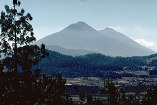
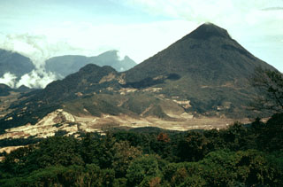
 Fuego (left) and Acatenango are seen here from the SSE in 1994. The two edifices erupted from four major vents along a 5-km-long N-S trend, with the focus of volcanic activity progressively shifting to the south. The modern Fuego edifice is constructed within the collapse scar of the ancestral Mesata edifice, located between it and Acatenango.
Copyrighted photo by Stephen O'Meara, 1994.
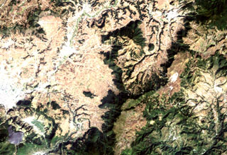
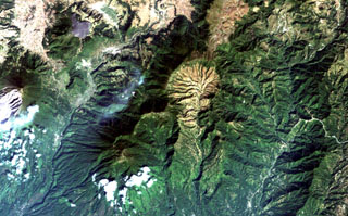 The light-colored, furrowed area at the top-center is the 4-km-wide, 600-m-deep Tzanjuyub caldera, which is breached to the south by the Río Masa. At the SW side of the Pleistocene caldera is Volcán Zunil, which is connected by an irregular ridge to Volcán Santo Tomás, a large eroded stratovolcano above the clouds at the bottom of the image. Santa María volcano (far left-center) lies across the Río Samalá to the east. Solfataras and thermal springs are located on the west side of the ridge between Santo Tomás and Zunil.
NASA Landsat image, 2000 (courtesy of Loren Siebert, University of Akron).
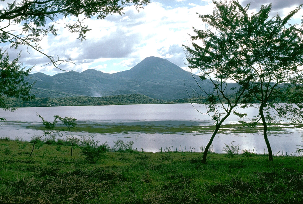
 Volcán de San Diego (upper right) is seen here from the south at the outlet of Lake Güija. The lake formed after lava flows from San Diego blocked the channel of the Desagüe river. Cerro el Tule (left) lies across a narrow channel from the lower flanks of San Diego. Cerro el Tule contains a summit crater and is one of the many cones of the San Diego volcanic field.
 Photo by Giuseppina Kysar, 1999 (Smithsonian Institution).
 A small lahar travels down the Barranca Honda valley on the eastern side of Fuego during the February-March 1973 eruption. The channel was also affected by pyroclastic flows during the relatively moderate 1972 eruption.
Photo by Bill Rose, 1973 (Michigan Technological University).
 Minor phreatic eruptions took place at Tacaná in February, May, and June 1986. Following a seismic swarm that began the previous day, a moderate phreatic explosion around noon on 8 May created a new 10-m-wide vent and ejected a small amount of fine ash. Vegetation was damaged over an area of 200 x 100 m. Vigorous steam emission was continuing at the time of this 25 June photo. The new vent formed at about 3,600 m elevation on the NE flank.
 Photo by Bill Rose, 1986 (Michigan Technological University).
 Santa María volcano is seen here in November 1994. The upper SW flank has a 1-km-wide crater formed during a catastrophic eruption in 1902. Two decades later the Santiaguito lava dome began growing at the base of the crater, forming the elongate ridge below the summit and to the left. Since 1922 the Santiaguito dome complex has exhibited frequent explosive activity accompanying episodic periods of dome growth and lava extrusion.
Copyrighted photo by Stephen O'Meara, 1994.
 Cerro Quemado is the youngest lava dome complex of Volcán de Almolonga and is seen here across the Llano del Pinal plain. Collapse of the NE flank about 1,150 years ago produced a debris avalanche deposit that forms the undulating topography in the foreground. An associated lateral blast also occurred across the Llano del Pinal. The eruption concluded with the emplacement of a small lava dome inside the avalanche scarp.
Photo by Lee Siebert, 1993 (Smithsonian Institution).
 Tajumulco is seen here from the NW from the slopes of Tacaná volcano, which lies along the México/Guatemala border. A lava flow from the NW summit traveled NW down a deep valley on the flank.
 Photo by Norm Banks, 1987 (U.S. Geological Survey).
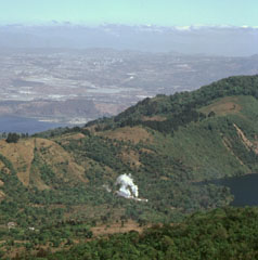 A steam plume rising from a geothermal site in Amatitlán caldera is seen here from the caldera rim of Pacaya, with Guatemala City in the background. Laguna Calderas contains the lake to the right and beyond the ridge to the left is part of Lake Amatitlán. The 14 x 16 km Amatitlán caldera produced a large number of major explosive eruptions that covered the current site of Guatemala City with pyroclastic flows during the late Pleistocene. The caldera retains a high heat flow that is being exploited for geothermal energy.
Photo by Paul Kimberly, 1999 (Smithsonian Institution).
 One of the most prominent topographic features of SE Guatemala is the figure-8-shaped double caldera of Ayarza volcano. Both calderas were formed within several thousand years of each other during major rhyolitic explosive eruptions in the late Pleistocene, about 27,000 years ago (eastern caldera) and 23,000 years ago (the larger western caldera). Formation of the older caldera was accompanied by the eruption of the chemically mixed pumices of the "Mixta" unit. The city of San Rafael las Flores, 6 km to the NE, is at the upper left.
 NASA Landsat image, 2000 (courtesy of Loren Siebert, University of Akron).
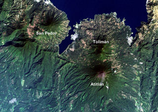
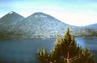 Volcán Tolimán (center) towers above the south shore of scenic Lake Atitlán. Tolimán and the adjacent Atitlán (upper left) were constructed within the Pleistocene Atitlán III caldera, near its inferred southern margin. In contrast to the tephra-covered surface of Volcán Atitlán, the surface of Tolimán is dominated by thick lava flows. The recent eruptions of Tolimán were primarily effusive eruptions from flank vents. The resulting lava flows extend into the lake and produce the irregular shoreline.
Photo by Bill Rose, 1972 (Michigan Technological University).
 Lobate lava flows from Tolimán volcano form the irregular shore jutting into Lake Atitlán. The Cerro de Oro cone is on the near shore to the upper right, and the NE wall of Atitlán caldera rises about 1 km above the far side of the lake. The town of Santiago Atitlán (foreground) lies near the mouth of Santiago Bay. The buried margin of Atitlán I caldera, the first of three Miocene-Pleistocene calderas at Atitlán, lies approximately below Cerro de Oro; the boundary of Atitlán II caldera lies just below the bottom of the photo.
Photo by Bill Rose, 1980 (Michigan Technological University).
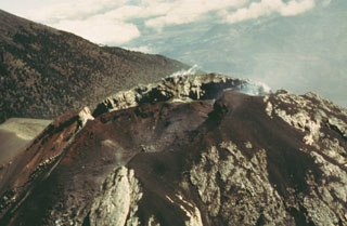
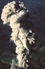
 An ash plume with incandescent ejecta rises high above the summit of Fuego and produces hot avalanches down its flanks during this 12-13 August 1966 eruption. Ash fills much of the sky in this view. The ash plume rose to 12 km during this large but brief eruption.
Photo by Dick Stoiber, 1966 (Dartmouth College).
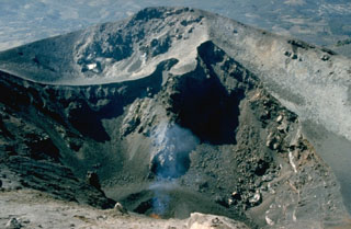
 This February 1967 photo, taken from near Cerro Chino on the northern caldera rim, shows the morphology of the MacKenney crater early in the long-lived eruption that began at Pacaya in 1965. Neary continuous explosive activity with periodic lava effusion first began on 4 July 1965 from a 250-m-wide pit crater that had formed in 1962 without eruptive activity.
Photo by Bill Rose, 1967 (Michigan Technological University).
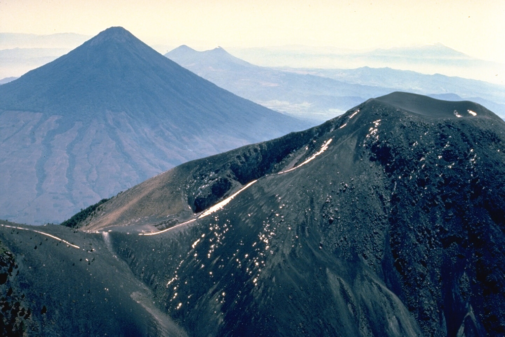
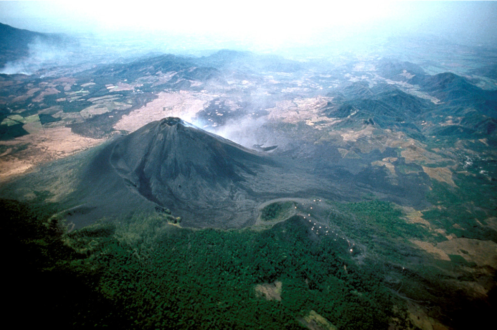
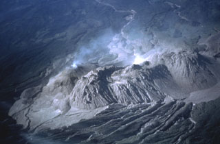
 An aerial view from the NNW shows gas emanating from the MacKenney cone. The rim of the large horseshoe-shaped crater within which the cone was constructed is visible in the foreground, partially covered by Cerro Chino scoria cone on the right. The crater formed by collapse of Pacaya during the late-Holocene and produced a debris avalanche that traveled down the Metapa river drainage to the SE, reaching as far as the Pacific coastal plain 25 km away.
Copyrighted photo by Stephen and Donna O'Meara, 1999.
 The triangular dark-green area (top-center) is the Cuxliquel lava-dome complex, lying within a semi-arcuate depression near the city of Totonicapán (upper right). The small green circle below and to the right of the larger dome complex is Cerro de Oro, a small symmetrical lava dome. The Río Samalá traces an arcuate path around the Quaternary dome complex beginning on its SE side (center) and progressing around to the north and then to the SW (bottom left). The white-colored area (left-center margin) is the city of Quetzaltenango.
NASA Landsat image, 2000 (courtesy of Loren Siebert, University of Akron).
 Volcán Ixtepeque, which is named after the Aztec word for obsidian, is seen here from the west. A 4 x 5 km rhyolitic obsidian lava flow field was erupted within the Ipala graben from a NE-trending vent . Obsidian from Ixtepeque has been found at archaeological sites across Central America.
Photo by Lee Siebert, 1993 (Smithsonian Institution).
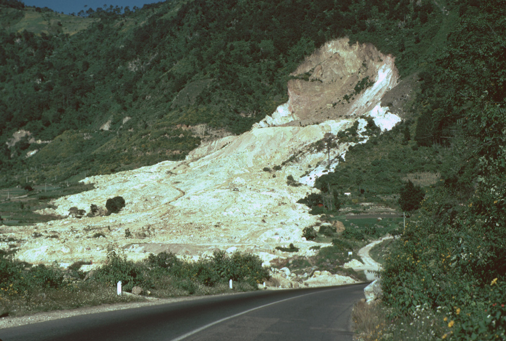
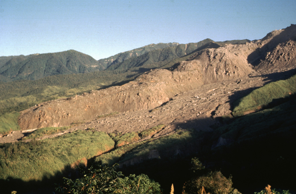
 An aerial view of the Río Las Majadas valley in Guatemala on the NNE side of Tacaná volcano shows thick deposits of lahars and debris avalanches filling the valley. These deposits provide a flat surface for agricultural use in deeply eroded terrain. The valley drains from its headwaters in Guatemala through México into the Pacific Ocean, and lahars during future eruptions could affect both countries.
Photo by Bill Rose, 1986 (Michigan Technological University).
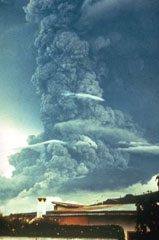 A large ash plume towers above Fuego in October 1974 as pyroclastic flows travel down the eastern flank (left). This was the largest Fuego eruption since 1932 at the time, and produced pyroclastic flows that traveled up to 7 km down the E, SE, SW, and W flanks. Prevailing winds distributed ashfall primarily to the SW, in the opposite direction from this view.
Photo by William Buell, 1974.
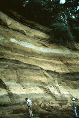
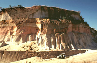 Thick units of the 84,000-year-old Los Chocoyos Ash are exposed south of Guatemala City, more than 100 km from its source at Atitlán caldera. Three units are visible here. The pinkish unit across the center of is the oxidized top of the pyroclastic flow deposit. The bottom two white units are the top and bottom halves of the deposit. The two fall deposits above the Los Chocoyos Ash are unit E from Amatitlán caldera and the younger unit C from Volcán de Agua.
Photo by Bill Rose, 1978 (Michigan Technological University).
 The steep walls of the 1902 explosion crater at Santa María expose a sequence of alternating thin (1-10 m) light-colored lava flows and brownish-colored block-and-ash flow deposits. Growth of the cone involved the extrusion of lava flows, mostly from the summit vent.
 Photo by Bill Rose, 1974 (Michigan Technological University).
 Cuxliquel volcano forms the triangular vegetated area in the center of this Planet Labs December 2019 satellite image monthly mosaic (N is at the top; the image is approximately 10 km across). The smaller vegetated area to the E is the Cerro de Oro lava dome. The surrounding area is the city of Quetzaltenango.
Satellite image courtesy of Planet Labs Inc., 2019 (https://www.planet.com/).
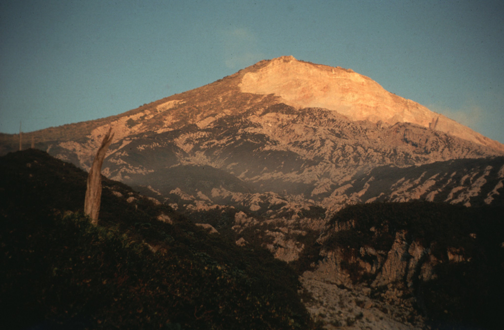
 The SW flank of 3772-m-high Santa María volcano, seen here from the west in March 1983, is cut on the right by a large crater produced during an eruption in 1902. The upper rim of the 1-km-wide crater extends to just below the summit. The diffuse smoke plume at the lower right is the remnant of an explosive plume from Santiaguito lava dome, which has been growing since 1922 at the base of the 1902 crater.
Copyrighted photo by Katia and Maurice Krafft, 1983.
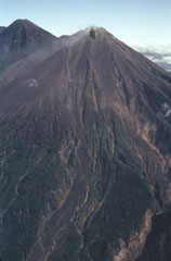
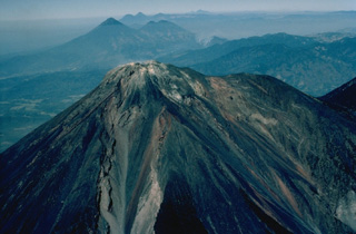
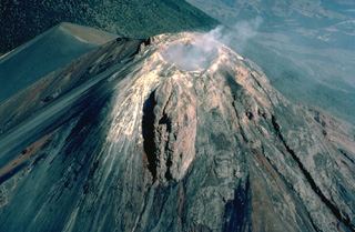
 An aerial view of the Fuego summit crater in 1990 shows the products of both effusive and explosive eruptions. The crater walls expose light-colored lava flows and lava agglutinate as well as darker scoria deposits. Historical eruptions have been basaltic in composition, continuing a trend towards more mafic in the Acatenango-Fuego volcanic complex. An Acatenango flank is to the left in this view from the SW.
Photo by Bill Rose, 1990 (Michigan Technological University).
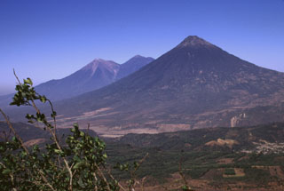
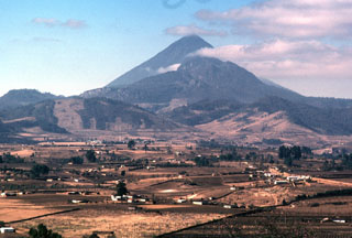
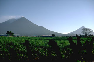 Three stratovolcanoes tower more than 3,500 m above the Guatemala Pacific coastal plain. Acatenango is the highest of the three, a small gas plume drifts from the summit of Fuego, and Volcán de Agua to the far right rises above a low saddle between it and Volcán de Fuego.
Photo by Lee Siebert, 1988 (Smithsonian Institution).
 The youngest vents of the Chiquimula volcanic field were erupted along a N-S-trending fracture north of the town of Chiquimula. They are seen here from the NE. The youngest lava flows originated from vents at Cerro Chiquito.
 Photo by Giuseppina Kysar, 1999 (Smithsonian Institution).
 Volcán Chingo is located along the Guatemala/El Salvador border. This aerial view is from the SW, the Guatemala side. The border with El Salvador extends from the bottom-right part of the photo through Volcán Chingo to Lake Guija at the upper left corner of the photo.
Photo by Paul Kimberly, 1999 (Smithsonian Institution).
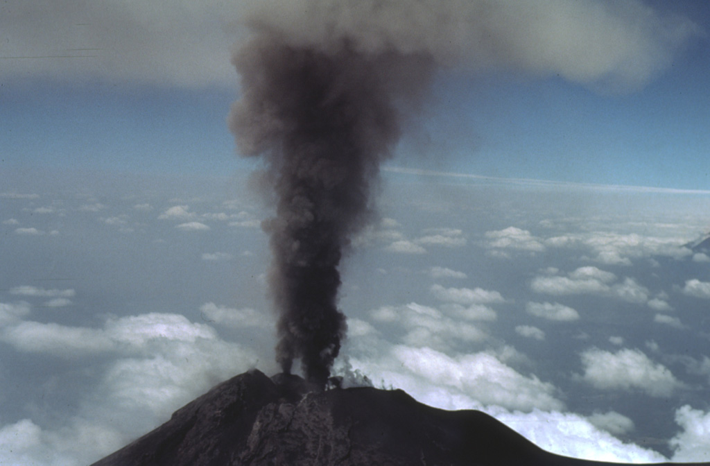
 The summit of Santa María provides this vantage point for viewing eruptions of the Santiaguito lava dome. This February 1988 ash plume rose from the vent to a height slightly above the summit. The brief 1-2 minute explosions produced light ashfall to within about 6 km of the vent.
Photo by Jon Fink, Arizona State University, 1988 (courtesy of Bill Rose, Michigan Technological University).
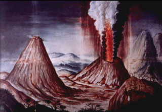 This contemporary painting of the 1775 Pacaya eruption of shows a lava fountain and ash plume rising above Cerro Chino. The perspective of the painting is from Meseta on the NE rim of Pacaya's large summit caldera. To the left is MacKenney cone, and to the far right is Volcán de Agua. An explosive eruption, one of the largest in historical time from Pacaya, began on 1 July 1775 and produced extensive ashfall and a lava flow.
 Anonymous painting (courtesy of Ministerio de Educación, Cultura y Deporte, Archivo General de Indias, Seville).
 The four major domes of the Santiaguito complex are seen here from the summit of Santa María in 1980. Caliente is degassing to the left, with La Mitad and El Monje in the center, and El Brujo to the right. The dacite dome complex stretches about 3 km in a roughly E-W direction. Lava flows and lahar channels extend down drainages from the dome complex to the south.
Photo by Bill Rose, 1980 (Michigan Technological University).
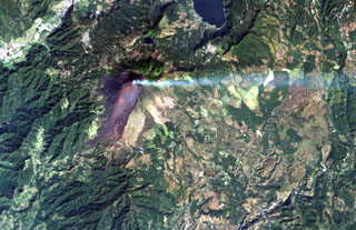 A volcanic plume extends to the east from MacKenney crater at Pacaya volcano in this December 8, 2000 Landsat image. The unvegetated modern cone was constructed within a scarp (visible south of the summit) left by a major edifice collapse at Pacaya volcano about 1100 years ago. The avalanche swept 25 km down the Río Metapa drainage (lower left) to the Pacific coastal plain. Pacaya was constructed near the southern rim of Amatitlán caldera, partially filled by Lake Amatitlán at the top right.
NASA Landsat image, 2000 (courtesy of Loren Siebert, University of Akron).
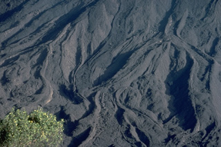 Fresh lava flows drape the slopes of MacKenney cone on Guatemala's Pacaya volcano. This March 1983 photo from Pacaya's caldera rim shows many individual flow lobes whose margins are outlined by prominent levees. A long-term eruption of Pacaya began in 1965. Frequent strombolian eruptions were often visible from Guatemala City, and lava flows such as these armored the slopes of the summit cone.
 Copyrighted photo by Katia and Maurice Krafft, 1983.
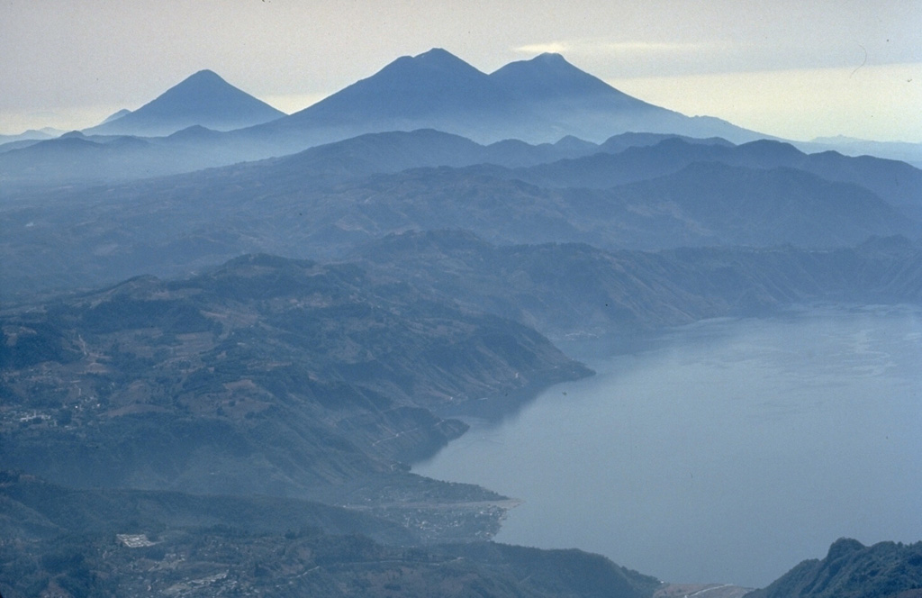
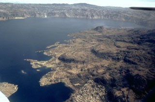
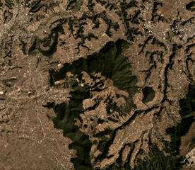
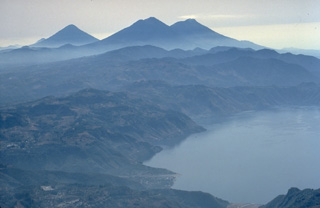
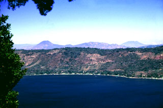
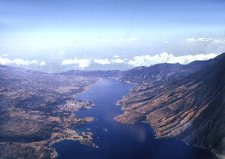
 Lake Atitlán fills the northern part of the Atitlán caldera complex. The caldera formed in three stages: Atitlán I caldera about 11 million years ago (Ma), Atitlán II caldera about 8 Ma, and Atitlán III caldera about 84,000 years ago. The southern margin of the first caldera lies near the southern shore of the 18-km-wide lake, San Pedro and Tolimán volcanoes were constructed over the southern margin of the second caldera, and Atitlán over the third.
NASA Landsat image, 2000 (courtesy of Loren Siebert, University of Akron).
 Spatter cones form when blobs of molten lava that are ejected from a vent solidify to form a steep-sided cone. This small spatter cone formed in MacKenney crater of Pacaya volcano in Guatemala on 10 February 1985, during an ongoing eruption that began in 1965. At the time of this photo, the spatter cone was 6-m high, ejecting incandescent volcanic bombs from its vent and extruding lava from its eastern (left) side.
Photo by Alfredo MacKenney, 1985.
 This view of Volcán Chingo from the SE side shows several smaller cones on the Salvador side of the volcano. Loma Los Siete Cerros is to the left, and the rounded cone of Cerro Laguneta to the right.
Photo by Giuseppina Kysar, 1999 (Smithsonian Institution).
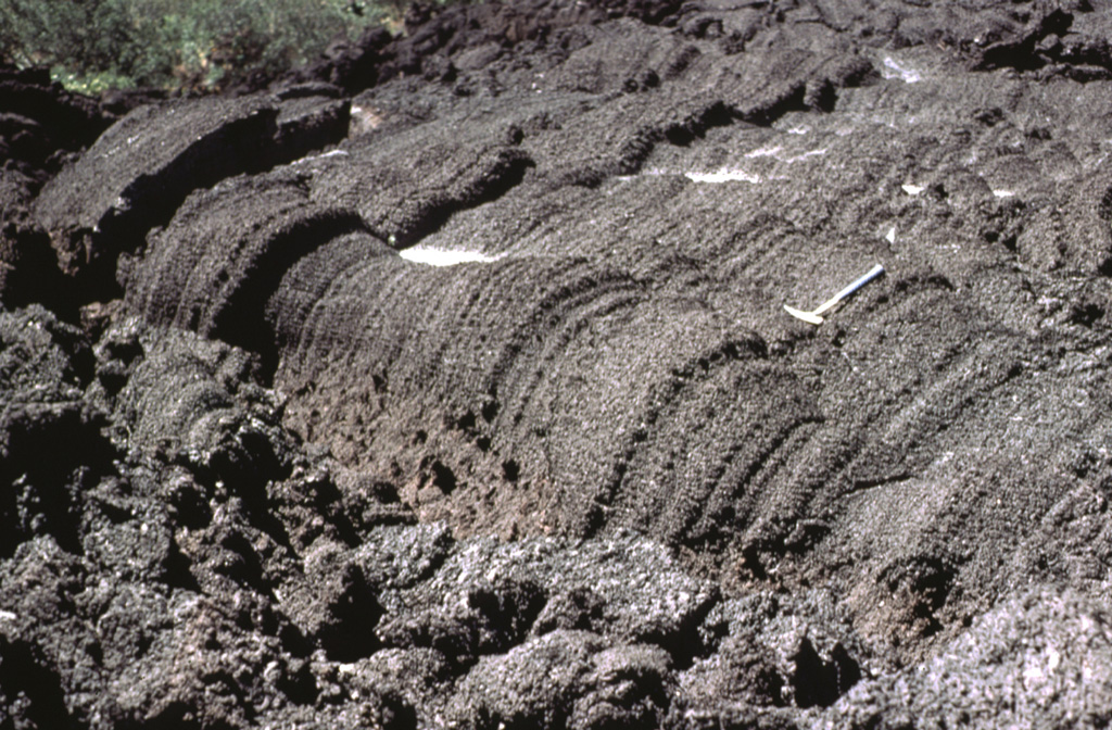
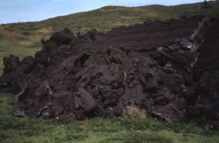 The front of the 1972 lava flow ends on grassy slopes on the southern flank of MacKenney cone at Pacaya. The rock hammer to the upper right provides scale next to the top of the flow front that formed when still-fluid lava was squeezed through an irregular crack in previously solidified crust.
Photo by Bill Rose, 1972 (Michigan Technological University).
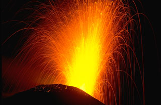 Strombolian explosions such as this one in November 1988 are typical at Pacaya. The ballistic traces of individual volcanic bombs that incrementally build MacKenney cone are seen in this time exposure. Cyclical activity lasting for several decades has consisted of long-term moderate explosive eruptions accompanied by periodic lava effusion that builds up the cone. This long-term moderate activity is punctuated by more infrequent larger explosions that destroy the upper part of the cone, after which the cone is reconstructed.
Photo by Lee Siebert, 1988 (Smithsonian Institution).
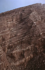
 A thick sequence of tephra layers, mostly from Acatenango, is exposed on the northern flank. Yepocapa, the northernmost of the two volcanic centers forming Acatenango, formed between about 70,000 and 43,000 years ago. Its major period of eruptive activity ended about 20,000 years ago, after which the activity of the southernmost center, Pico Mayor, commenced.
Photo by Bill Rose, 1987 (Michigan Technological University).
 In May 1981 lava flows overtopped a notch in the NW rim of MacKenney crater and flowed down the northern flank. This view from Meseta on the caldera rim shows multiple individual flow lobes with levees. The dark lava field to the right contrasts with the tephra-covered slopes of the cone to the left. This period of frequent lava extrusion lasted from 9 May until 2 June.
Photo by Bill Rose, 1981 (Michigan Technological University).
 The twin volcanoes of Acatenango (left) and Fuego rise in the center beyond Lake Atitlán, with the conical peak of Agua volcano to their left. Lake Atitlán fills the latest of three large calderas produced during the Pleistocene at Atitlán. A steam plume originates from the summit of Fuego, one of Guatemala's most active volcanoes.
 Copyrighted photo by Katia and Maurice Krafft, 1983.
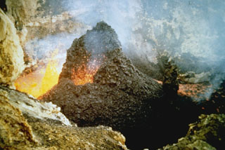
 A small spatter cone ejects incandescent lava bombs at the bottom of MacKenney crater in early February 1990. Activity had resumed at Pacaya in early January after a long quiescence following a major explosive eruption 7-10 March 1989. This eruption removed the upper 75 m of MacKenney cone and enlarged the 50 x 75 m crater to the 200 x 350 m seen here.
Photo by Alfredo MacKenney, 1990.
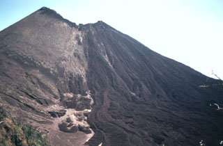
 Frequent explosive eruptions have kept the summit of Fuego unvegetated. Historical lava flows that originated from the summit crater descended through forests down the Río Taniluya (left) and the Río Ceniza (right) on the SW flank. Acatenango is to the left.
Photo by Bill Rose, 1980 (Michigan Technological University).
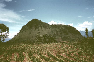
 Tecuamburro, seen here from the SE on the Pacific coastal plain, is a small lava-dome complex of mostly Pleistocene age. Tecuamburro and other lava domes forming the right-hand peaks were constructed during the late Pleistocene or early Holocene within a horseshoe-shaped, east-facing crater. The crater resulted from structural failure of the older Miraflores stratovolcano on the left.
 Photo by Lee Siebert, 1988 (Smithsonian Institution).
 The floor of the 5-km-wide Retana caldera between Suchitán and Tahual volcanoes is now used for farmland. The caldera walls range up to 250 m in height, with a low notch on the northern rim (left).
 Photo by Lee Siebert, 1993 (Smithsonian Institution).
 This view from Pacaya shows Fuego and Acatenango (left) and conical Volcán de Agua volcano (right). These impressive volcanoes all exceed 3.5 km in elevation and rise from near sea level on the Pacific coastal plain to the south. Volcanism at the Acatenango-Fuego pair has migrated southwards, and Fuego, its summit kept free of vegetation by frequent eruptions, is one of Guatemala's most active volcanoes.
Photo by Lee Siebert, 1999 (Smithsonian Institution).
 Tolimán volcano is 4 km away beyond the summit of Atitlán. Atitlán was constructed over the approximate rim of the Atitlán III caldera, whereas Tolimán was built over the margin of Atitlán II caldera. The irregular Lake Atitlán shoreline to the left is formed by lava flows from Tolimán. The far Atitlán III caldera rim can be faintly seen across the lake. The two post-caldera cones have dramatically different eruptive styles, with lava flows dominating at Tolimán and pyroclastic eruptions at Atitlán.
 Photo by Bill Rose, 1983 (Michigan Technological University).
 A rockfall descends the S flank of the Caliente dome of the Santiaguito dome complex at Santa Maria volcano on 28 February 2020, causing a small ash plume to rise above it. The Santa Maria edifice is behind and just right of the dome, with the large 1902 crater wall extending down its SW flank.
Photo by Ailsa Naismith, 2020.
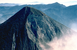
 Tacaná lies about 30 km south of the Polochic‐Motagua fault, in the zone which marks the Caribbean and North American plate boundary. The summit, seen here from the SSE, is elongated as a result of the extrusion of a series of lava domes with the youngest center, San Antonio, being at the SW (left). In the center is the Tacaná itself, with Chichuj to the right.
Photo by Norm Banks, 1987 (U.S. Geological Survey).
 A small blocky lava dome within the Caliente vent on the Santiaguito lava dome of Guatemala's Santa María volcano on 18 July 1969. This was near the beginning of a period of renewed activity at this vent. Growth of the composite Santiaguito lava dome has been ongoing since 1922.
Photo by Dick Stoiber, 1969 (Dartmouth College).
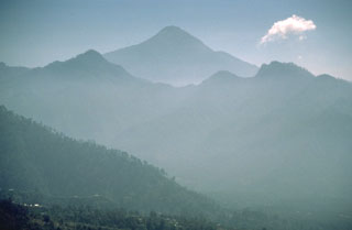
 The deep valley cutting across the center of the photo is the elongated breached caldera of Siete Orejas volcano. It is seen here from the SE from near the summit of Santa María volcano. Light-colored areas on the caldera rim are voluminous rhyodacitic pumice deposits from Siete Orejas. Tacaná volcano on the México/Guatemala border is on the left-center horizon, and Tajumulco is visible to its right. These are the two highest volcanoes of Guatemala.
Photo by Bill Rose, 1972 (Michigan Technological University).
 Volcán Las Viboras, north of Volcán Chingo, is a part of the Chingo volcanic field in Guatemala. Las Viboras (seen here from the north) contains a scoria cone at the summit. Recent lava flows of estimated Holocene age were erupted along this same fault on the N flank of Las Viboras and on the NW flank.
Photo by Giuseppina Kysar, 1999 (Smithsonian Institution).
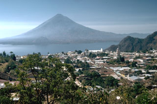
 The northern wall of Coatepeque caldera rises about 250 m above the surface of Lago de Coatepeque, whose shores are lined with residences and small hotels. The peak beyond the caldera to the left is Volcán Chingo along the El Salvador/Guatemala border. The broader peak to the far right is Volcán Suchitán, one of the largest volcanoes in SE Guatemala.
 Photo by Lee Siebert, 2002 (Smithsonian Institution).
 Santa Maria is seen here from Siete Orejas volcano. The SW (right-hand) flank of Santa María is slightly influenced by the profile of the massive crater produced by the 1902 eruption. The forested peak on the lower NE flank of Santa María is Volcán del Valle, an eroded scoria cone. Behind it is Santo Tomás volcano. Light-colored pumice deposits from the 1902 Santa María eruption and a Pleistocene eruption of Siete Orejas volcano are visible in the foreground.
Photo by Bill Rose, 1975 (Michigan Technological University).
 The Santiaguito lava-dome complex (center) has been in continual activity since 1922. It is seen here in March 1983 from the SE, with Siete Orejas volcano forming the broad forested ridge above it and Tacaná (left) and Tajumulco (right) volcanoes appearing on the left skyline. Santiaguito was constructed within the large 1902 explosion crater, which cuts the SW flank of Santa María volcano at the right.
Copyrighted photo by Katia and Maurice Krafft, 1983.
 Volcán Tahual rises about 700 m above plains south of the town of Monjas, seen here from the NE. The summit contains a broad erosional depression that opens at the NE base of the volcano (center). A Holocene cone near the NE base of Volcán Tahual produced a short lava flow, now vegetated to the right.
Photo by Lee Siebert, 1993 (Smithsonian Institution).
 Cerro de Oro is a lava dome that was constructed on the northern flank of Tolimán, near the southern shoreline of Lake Atitlán. Lava flows from Cerro de Oro extend into the lake and may be as young as a few thousand years. The dome's name (which means Hill of Gold) reflects local belief that it contains buried treasure.
Photo by Bill Rose, 1972 (Michigan Technological University).
 The summit of Fuego volcano is seen here from the ESE, looking along the chain of large stratovolcanoes stretching across Guatemala. The shoulder to the right of Fuego is a remnant of Meseta volcano, whose growth and collapse preceded formation of the modern cone of Fuego. Behind its summit are the paired volcanoes of conical Atitlán (left) and Tolimán, with a lower double summit. Above the saddle between them are Pleistocene Santo Tomás (left) and the frequently active Santa María (right). Tajumulco is on the skyline just right of center.
Copyrighted photo by Katia and Maurice Krafft, 1983.
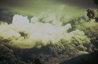 Ash rises above a pyroclastic flow racing down the eastern flank of Fuego in October 1974 that fills the entire field of view. The direction of movement of the pyroclastic flow was from right to left. Pyroclastic flows of comparable magnitude also traveled down the W and SW flanks.
Photo by William Buell, 1974.
 The summit of Atitlán volcano contains shallow craters in this 1980 photo. San Pedro volcano rises across Santiago bay to the right, and in the distance (left-to-right) are the peaks of Santo Tomás, Santa María, and Tajumulco. Atitlán is the highest of the three post-caldera cones of Atitlán caldera.
Photo by Bill Rose, 1980 (Michigan Technological University).
 Cerro Quemado is seen here with Santa María towering directly behind it. An eruption of Cerro Quemado, part of the Almolonga lava dome complex, took place in 1818. The lava flow that forms the left-hand ridge of Cerro Quemado in this view from the NE was extruded from the east-central flank and traveled 2.5 km towards the towns of Zunil and Almolonga. Minor explosive eruptions accompanied the extrusion and produced ashfall on nearby hills.
Photo by Lee Siebert, 1993 (Smithsonian Institution).
 Atitlán and Tolimán volcanoes rise above Lake Atitlán in this view from the town of Sololá north of the lake. Atitlán is the taller of the two and forms the skyline immediately behind and to the left of Tolimán. The Cerro de flank lava dome immediately above the lakeshore to the lower left of the summit erupted within the past few thousand years. The two volcanoes were constructed over the buried rims of two Miocene-Pleistocene Atitlán calderas.
Photo by Lee Siebert, 1988 (Smithsonian Institution).
 The Jumay Volcanic Field includes the cone in the center of this December 2019 Planet Labs satellite image monthly mosaic (N is at the top; the image is approximately 20 km across), N of Jalapa city. This cone has a shallow crater and eroded flanks.
Satellite image courtesy of Planet Labs Inc., 2019 (https://www.planet.com/).
 MacKenney cone, the historically active vent of Pacaya volcano in Guatemala, was constructed within a horseshoe-shaped crater produced by collapse of the summit of an ancestral volcano about 1,100 years ago. The SW crater rim forms the steep-sided scarp at the right. The blocky hill in the foreground is a hummock from the debris avalanche produced by the collapse. The avalanche extended for 25 km.
Photo by Lee Siebert, 1988 (Smithsonian Institution).
 Santiago Bay in Lake Atitlán is the result of encroachment by the flanks of three post-caldera volcanoes into the lake. The narrow channel extends about 8 km to the low southern caldera wall and is about 1 km wide. To the right are the San Pedro flanks, the oldest of the post-caldera stratovolcanoes. Contrasting eruptive styles produced the irregular shoreline in the left foreground consisting of lava flows from Tolimán and the smoother shoreline to the right, formed by pyroclastic deposits from Atitlán.
Photo by Bill Rose, 1980 (Michigan Technological University).
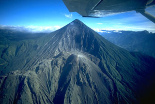
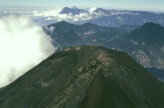
 Steam rises above the summit of Volcán Fuego, one of Guatemala's most active volcanoes, seen here in March 1983 from the SW. Thick masses of lava agglutinate and short lava flows armor parts of the upper cone. The ash-covered shoulder left of the summit is the rim of Meseta. The modern Fuego cone was constructed during the last 8500 years within an arcuate scarp left by collapse of Meseta volcano. The forested slope at the upper left is that of Acatenango volcano.
Copyrighted photo by Katia and Maurice Krafft, 1983.
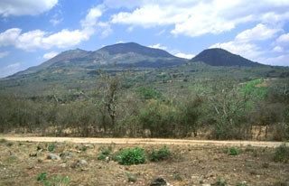 Ipala rises about 750 m above the floor of the Ipala graben. The edifice extends nearly across the full width of the graben. The cone to the right is Monte Rico on the southern flank. The eastern flank contains a 17 km NNE-SSW-trending vent that produced a line of Holocene scoria cones and lava flows out of view to the right.
Photo by Giuseppina Kysar, 1999 (Smithsonian Institution).
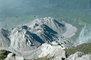 The Santiaguito lava dome has been continually growing since 1922, seen here in December 1993 from the summit of Santa María. Episodic periods of increased growth have occurred from different vents on the dome complex. The Caliente vent is partially seen at the far left, with La Mitad, El Monje, and El Brujo vents located farther west along the 3-km-long crest of Santiaguito.
Photo by Lee Siebert, 1993 (Smithsonian Institution).
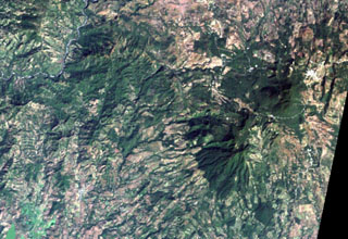 The large forested area at the middle right is the 1662-m-high Moyuta volcanic complex, its summit composed of a series of overlapping andesitic lava domes. The small white-colored area above and to the right of the dome complex is the city of Moyuta, which lies at an altitude of nearly 1300 m. Moyuta is the easternmost of the chain of large stratovolcanoes stretching across the Guatemalan Highlands.
NASA Landsat image, 2000 (courtesy of Loren Siebert, University of Akron).
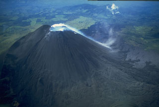 Gas emissions from the summit crater of the MacKenney cone of Pacaya descends its SW flank in this 10 November 1994 photo. Powerful explosions during 7-10 March 1989 that destroyed the upper 75 m of MacKenney cone, after which Strombolian activity resumed in early January 1990.
Copyrighted photo by Stephen O'Meara, 1994.
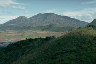 Suchitán volcano, seen here from the west on the rim of Retana caldera, is the highest of a group of closely spaced small volcanoes including scoria cones in SE Guatemala. The large peak to the left of the summit is Cerro Mataltepe; other scoria cones occur lower on the north flank. One of the more recent lava flows from Suchitán traveled through a low notch in the eastern caldera rim. The caldera once contained a lake, but now is used for agricultural land.
Photo by Lee Siebert, 1993 (Smithsonian Institution).
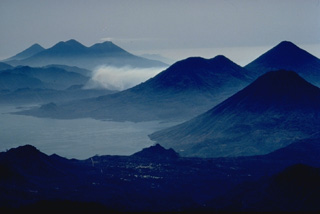 This dramatic photo looking SE down the axis of a chain of volcanoes extending across Guatemala shows six Quaternary volcanoes and one large caldera. Beginning in the right foreground are three volcanoes, San Pedro, the conical Atitlán, and Tolimán, that are constructed on the southern shore of Lake Atitlán, which fills a large Pleistocene caldera. The three volcanoes in the distance are, from left to right, Agua, Acatenango, and Fuego. Tolimán-Atitlán and Acatenango-Fuego are paired volcanoes along N-S lines.
Copyrighted photo by Katia and Maurice Krafft, 1983.
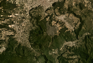 Cerro Quemado is a complex of lava domes and flows, including the unvegetated 1818 deposit in the center of this August 2019 Planet Labs satellite image monthly mosaic (N is at the top; this image is approximately 12 km across). It is part of the Almolonga volcanic group that includes the caldera of Volcán de Almolonga to the E and a series of domes to the N. The city of Quetzaltenango is visible to the N.
Satellite image courtesy of Planet Labs Inc., 2019 (https://www.planet.com/).
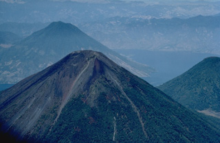 Volcán Atitlán, seen here from the SE with San Pedro volcano behind it and Tolimán volcano to its left, is a conical stratovolcano that rises to 3535 m south of Lake Atitlán (right). The historically active Atitlán is younger than Tolimán, although their activity overlaps. The northern side of the volcano is wooded to near the summit, whereas the upper 1000 m of the southern slopes, seen here, are unvegetated. Predominatley explosive eruptions have been recorded from Volcán Atitlán since the 15th century.
Copyrighted photo by Katia and Maurice Krafft, 1983.
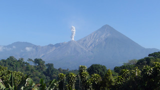 This 28 February 2020 photo shows typical degassing at El Caliente dome producing a vertical gas plume. The dome is one of four that form the Santiaguito dome complex at Santa Maria, with the 1902 crater wall behind it.
Photo by Ailsa Naismith, 2020.
 This view from the south shows a forested lava dome, one of a cluster of at least three coalescing domes that form the summit of Moyuta. The town of Moyuta, the outskirts of which are seen in the center of the photo, is located high on the volcano immediately adjacent to the summit dome complex.
Photo by Lee Siebert, 1988 (Smithsonian Institution).
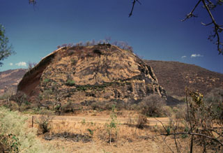 Cerro Quemado scoria cone near of the outlet of Lake Güija has been extensively quarried, and only a remnant remains. The San Diego volcanic field is along the El Salvador/Guatemala border and contains numerous scoria cones and associated lava flows on both sides of Lake Güija.
Photo by Giuseppina Kysar, 1999 (Smithsonian Institution).
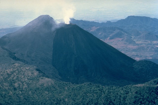 Eruptions from Pacaya, one of Guatemala's most active volcanoes, are frequently visible from Guatemala City, the nation's capital. The modern Pacaya volcano (MacKenney cone) has grown within an arcuate caldera rim (visible at the lower part of this 1983 photo from the NE) that was created by a massive landslide. During the past several decades, activity at Pacaya has consisted of frequent strombolian eruptions with intermittent lava flow extrusion on the flanks of McKenney cone, punctuated by occasional larger explosive eruptions.
 Copyrighted photo by Katia and Maurice Krafft, 1983.
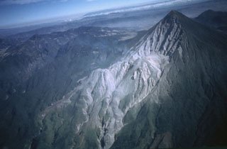 An aerial view from the SE shows the Santiaguito lava dome complex at the base of the 1.5-km-wide 1902 crater on the SW flank of Santa María. Lava flows from the Caliente dome at the eastern side of Santiaguito descend to the bottom center of the photo; lava flows from the western El Brujo vent are visible at the lower left. The broad volcano to the upper left is Siete Orejas.
 Photo by Bill Rose, 1980 (Michigan Technological University).
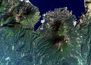 The 6-km-long, dagger-like Santiago Bay on Lake Atitlán is constrained by lava flows from San Pedro (upper left) and Tolimán (right-center) volcanoes. Young lava flows entering the lake, in particular those from Tolimán, have created a very irregular shoreline. The unvegetated summit of Atitlán volcano, the youngest post-caldera stratovolcano, lies south of Tolimán. Part of the southern margin of the Atitlán III caldera, which lies below the summit of Atitlán volcano, is offset along faults just south of the tip of Santiago Bay.
NASA Landsat image, 2000 (courtesy of Loren Siebert, University of Akron).
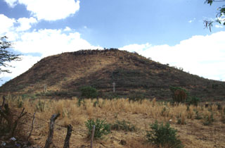 A group of scoria cones and low-elevation edifices surrounds the city of Jutiapa in SE Guatemala. This photo shows Volcán Culma, a cone largely composed of basaltic lavas on the eastern side of the city. The most prominent feature of the volcanic field is Cerro Santiago, one of two coalescing scoria cones SE of Jutiapa.
 Photo by Giuseppina Kysar, 1999 (Smithsonian Institution).
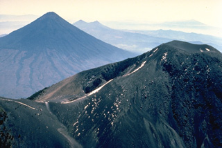 This photo looking SE across the volcanic chain of Guatemala shows Fuego volcano, lightly dusted with snow, in the foreground, and the symmetrical Agua volcano at the upper left. Twin-peaked Pacaya volcano is located behind the right flank of Agua, and the broad massif in the distance above the summit of Fuego is Tecuamburro volcano. Fuego and Pacaya are two of Guatemala's most active volcanoes.
Copyrighted photo by Katia and Maurice Krafft, 1983.
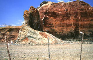 Volcanic dikes of varying orientations were emplaced into oxidized red scoria in a quarried scoria cone near the village of Agua Blanca. Several generations of thin dikes are visible (note people at the lower left for scale). The larger dike supporting the pinnacle near the center is oriented north-south, parallel to the direction of faults defining the Ipala graben.
Photo by Giuseppina Kysar, 1999 (Smithsonian Institution).
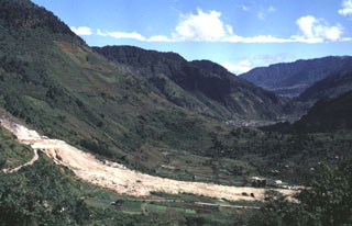 The light-colored area in the foreground is a landslide from the Almolonga volcano Zunil geothermal field that occurred on 5 January 1991. The landslide traveled 800 m from its source along the Zunil fault zone toward the Río Samalá and killed 23 people living on the valley floor and cut off the highway between Quetzaltenango and the Pacific coast. Some of the survivors of the slide were treated for burns from the hot flow. This view looks along the Río Samalá valley to the NE with the flanks of Cerro Quemado in the background to the left.
Photo by Carlos Pullinger, 1993 (Servicio Nacional de Estudios Territoriales, El Salvador).
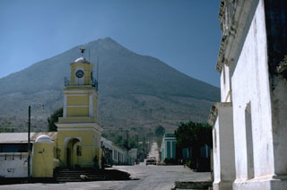 Volcán de Agua seen to the east above the ancient capital city of Ciudad Vieja. A lahar from Agua in 1541 CE destroyed this city, the first capital established by the Spanish. The catastrophe caused the capital city to be relocated to nearby Antigua Guatemala.
Photo by Lee Siebert, 1988 (Smithsonian Institution).
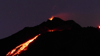 Lava flows down the upper eastern flank of Pacaya are visible in this photo from the night of 17 February 2020. Incandescent lava fountaining from the active Mackenney cone above is the source of the flow.
Photo by Ailsa Naismith, 2020.
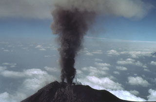 Two ash plumes rise simultaneously from small vents in the Fuego summit crater on 27 February 1978. This view is from the NE with the Pacific coastal plain in the background. Intermittent minor eruptions took place from 11 September 1977 to 8 August 1979. Strombolian eruptions from vents in the crater formed small cones and produced incandescent fountains at night.
Photo by Bill Rose, 1978 (Michigan Technological University).
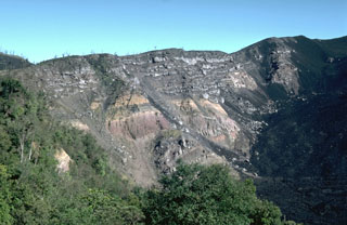 Large-scale collapse of the Pacaya summit sometime between about 1,550 and 600 years ago created a large horseshoe-shaped scarp. Collapse was followed by a large explosive eruption that produced widespread pyroclastic surges. This roughly 150-m-high section of the NW scarp exposes light-colored lava flows overlying pyroclastic deposits of the pre-collapse edifice. Subsequent eruptions have constructed a new cone within the caldera. Lava flows from MacKenney cone (out of view to the right) are slowly filling in the caldera moat.
Photo by Lee Siebert, 1988 (Smithsonian Institution).
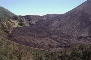 Lava flows erupted in September 1998 cover the floor of the caldera moat of Pacaya. The caldera wall here is about 100 m high. Frequent lava flows from MacKenney cone, whose flank is to the right, have been gradually forming deposits to tens of meters higher than it was a decade ago. Eruptions at MacKenney cone have been frequent since its initial eruption in 1965. The ridge in the foreground is the crater rim of Cerro Chino.
Photo by Paul Kimberly, 1999 (Smithsonian Institution).
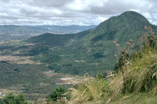 Cerro Quemado, seen here from the SW, is the youngest lava dome complex of Volcán de Almolonga. It is located immediately south of Guatemala's second largest city, Quezaltenango, the outskirts of which are visible to the upper left. The dome complex consists of a series of domes and flows.
Photo by Lee Siebert, 1993 (Smithsonian Institution).
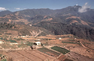 Volcán Santo Tomás is a large eroded stratovolcano seen here to the east across the valley of the Río Samalá from the Zunil geothermal site. The summit of Volcán de Zunil is 4.5 km to the NE. Geothermal fields are located on the NW Santo Tomás flank and 3 km north along the ridge to the Zunil summit.
Photo by Bill Rose, 1981 (Michigan Technological University).
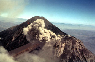 Winds deflect a small 27 February 1978 ash plume from the Fuego summit crater to the west. In the background is Acatenango, which rises about 700 m above the saddle between it and Fuego. Intermittent minor eruptions took place from 11 September 1977 to 8 August 1979, sometimes producing pyroclastic flows and lava flows.
Photo by Bill Rose, 1978 (Michigan Technological University).
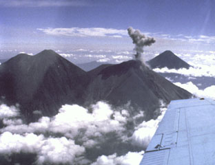 Intermittent explosions took place at Fuego during a two-year-long period beginning in September 1977. Here an ash plume is rising above the summit of Fuego on 11 February 1978. This view is from the WSW, with Acatenango to the left and Agua in the background in 1978. The height of the eruption plume can be compared to the roughly 700 m vertical distance between the summit of Acatenango and the saddle between it and Fuego.
Photo by Ray Chuan, 1978 (courtesy of Bill Rose, Michigan Technological University).
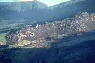 A dacitic lava flow that traveled to the SW from El Brujo vent of Santiaguito is seen in April 1963, a month after it ceased flowing. The slow-moving lava flow is approximately 50 m thick and extended about 1.5 km from the vent. El Brujo, near the western end of the Santiaguito dome complex of Guatemala's Santa María volcano, is the youngest at Santiaguito and was the focus of increased effusive activity from 1959 to 1963.
Photo by Dick Stoiber, 1963 (Dartmouth College).
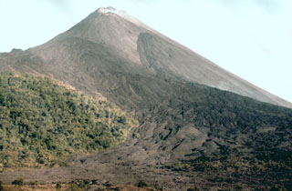 Recent lava flows cover the NW flank of Pacaya. Two prominent flow fields originating from flank vents can be seen in this 1987 photo. The vegetated slopes to the left are below Cerro Chino, a scoria cone on the rim of Pacaya's large horseshoe-shaped crater.
Photo by Klaus Mehl, 1987 (GEOMAR, Germany).
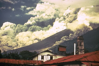 Pyroclastic flows travel down the east flank of Fuego volcano in Guatemala during October 1974 as part of one of the largest historical eruptions of the volcano. Ash plumes rise from the pyroclastic flows, which traveled up to 7 km from the summit at estimated average velocities of 60 km/hour. The denser basal portion of the pyroclastic flow follows topographic lows on the flanks of the volcano. A smaller pyroclastic flow is descending the gully to the right.
Photo by William Buell, 1974.
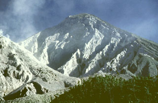 The eroded headwall of the 1.5-km-wide 1902 crater extends from just below the summit down to 2.2 km elevation, where a volume of 0.5 km3 was removed during the eruption. The Santiaguito lava dome complex (left) began growing in the new crater in 1922. This 1991 view shows a lava flow descending the right flank of the dome.
Photo by Bill Rose, 1991 (Michigan Technological University).
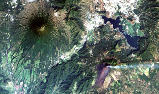 Steaming Pacaya volcano (lower right) lies across a valley from symmetrical Agua volcano (upper left). Pacaya was constructed near the southern margin of Amatitlán caldera, whose SE rim lies near the right-center margin. The 14 x 16 km wide caldera was formed during a series of major silicic explosive eruptions between about 300,000 and 23,000 years ago. The irregular margins of Lake Amatitlán are constrained on the SW side by post-caldera lava domes. The outskirts of Guatemala City lie at the upper right.
NASA Landsat image, 2000 (courtesy of Loren Siebert, University of Akron).
 An ash plume rises from the summit crater of Fuego in this March 1978 photo. Intermittent minor explosive eruptions took place from 11 September 1977 to 8 August 1979. The eruptions sometimes produced pyroclastic flows and lava flows, and originated from multiple vents in the summit crater.
Photo by Dick Stoiber, 1978 (Dartmouth College).
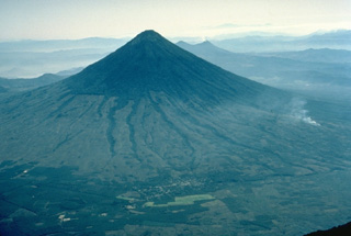 The symmetrical, forested Volcán de Agua stratovolcano forms a prominent backdrop to both the historic former capital city of Antigua Guatemala and Guatemala City, the present capital. The 3760-m-high Agua volcano has a small, circular crater that is breached on the NNE side. Agua has had no historical eruptions, but a devastating mudflow on September 11, 1541, destroyed the first Guatemalan capital city, now known as Ciudad Vieja. This view from the NW also shows the twin-peaked Pacaya volcano behind the upper right flank of Agua.
Copyrighted photo by Katia and Maurice Krafft, 1983.
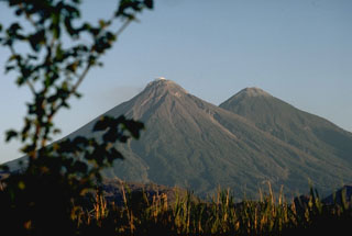 Fuego (left) and Acatenango are two of several paired volcanoes in Guatemala. Activity from the Pleistocene-Holocene Acatenango has continued only sporadically into historical time, but Fuego is one of the most active volcanoes in Guatemala with about 60 historical eruptions.
Photo by Lee Siebert, 1988 (Smithsonian Institution).
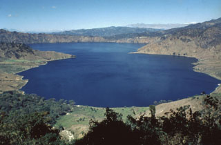 Ayarza, a scenic double caldera filled by Laguna de Ayarza, is seen here from the ESE. The peninsulas of Punta el Picacho (left) and Punta el Picachito (right) lie across an 800-m-wide channel separating the two halves of the 5 x 7 km wide, figure-8-shaped caldera. Both calderas, whose steep walls rise nearly 600 m above the lake surface, were formed within several thousand years of each other during major rhyolitic explosive eruptions in the late Pleistocene between about 27,000 and 23,100 years ago.
 Photo by Bill Rose, 1980 (Michigan Technological University).
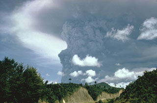 Following mild eruptions that began on 7 February 1966, a powerful eruption in April produced this ash plume that towers above the summit (not visible in this view). Major eruptions during 20 April to 1 May were accompanied by pyroclastic flows and lava flows.
Photo by Bill Rose, 1966 (Michigan Technological University).
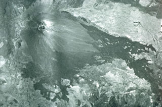 Vegetation-free MacKenney cone was constructed within a large 3 x 6 km crater. The eastern (right) and northern (top) rims are visible in this photo, and formed as a result of massive slope failure of an ancestral Pacaya edifice. Lava flows from MacKenney cone traveled to the west and south beyond the crater.
Aerial photograph by Instituto Geográfico Nacional, 1981.
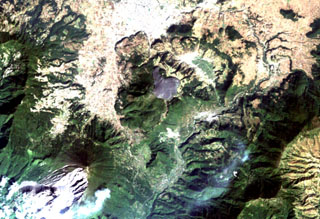 The arcuate area at the top center below the light-colored city of Quetzaltenango is the Almolonga volcanic complex. An arcuate series of lava domes outlines the northern part of the complex, while the unvegetated area to the south is the 1818 lava flow from Cerro Quemado volcano, the youngest of the Almolonga complex. Almolonga is located along the Zunil fault zone, which extends diagonally SW along the Río Samalá (bottom-center). The furrowed 1902 crater of Santa María volcano lies at the lower left.
NASA Landsat image, 2000 (courtesy of Loren Siebert, University of Akron).
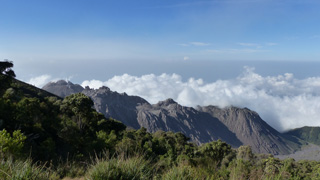 This view from the lookout point on the W flank of Santa Maria shows the Santiaguito dome complex on 27 February 2020. From left to right (approximately NE-SW) the domes are El Caliente, La Mitad, El Monje, and El Brujo.
Photo by Ailsa Naismith, 2020.
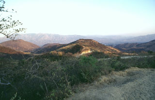 The Chiquimula volcanic field occupies a fault-bounded basin in the Chiquimula Valley of SE Guatemala. Recent eruptions produced basaltic scoria cones and lava flows constructed along a N-S-trending fracture starting near the northern edge of Chiquimula town. Part of the town is seen on the valley floor to the right of the hill in the center of this photo, taken from the NW along the road to Maraxco.
Photo by Giuseppina Kysar, 1999 (Smithsonian Institution).
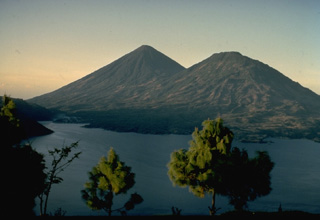 Atitlán (left) and Tolimán (right) are twin stratovolcanoes on the shores of Lake Atitlán, one of the scenic highlights of Guatemala. The historically active Atitlán is younger than Tolimán, although their activity overlaps. The surface of Tolimán is draped by prominent thick lava flows, in contrast to the extensive pyroclastic cover on Atitlán. Tolimán lava flows, erupted from both summit and flank vents, have produced a pronounced embayment with an irregular shoreline that extends into the lake. This view is from the NE on the rim of Atitlán caldera.
Copyrighted photo by Katia and Maurice Krafft, 1974.
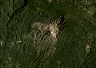 Santa Maria is the large edifice with the broad 1902 crater in the center of this August 2019 Planet Labs satellite image monthly mosaic (N is at the top; this image is approximately 12 km across). The Santiaguito dome complex in comprised of Caliente, the large lava dome in the center of the image, then La Mitad, El Monje, and El Brujo domes from E to W.
Satellite image courtesy of Planet Labs Inc., 2019 (https://www.planet.com/).
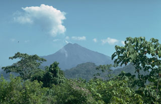 The flanks of Pacaya rise above foothills at the margin of the Pacific coastal plain of Guatemala. The summit is MacKenney cone, which was constructed within a collapse crater produced by the gravitational failure of an ancestral Pacaya edifice. The resulting debris avalanche traveled 25 km from the volcano to near the village of Las Chapernas on the coastal plain, beyond the point of this photo.
Photo by Lee Siebert, 1988 (Smithsonian Institution).
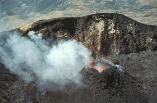 Incandescent lava spatter is ejected from a small cone in MacKenney crater in February 1981. Lava flows from the cone filled the crater floor and flowed out through a notch in the crater rim.
Photo by Bill Rose, 1981 (Michigan Technological University).
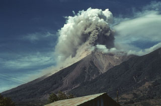 Prevailing winds disperse an ash plume from Fuego to the SW in December 1978 as a small pyroclastic flow descends the SE (left) flank. Intermittent minor eruptions took place over a two-year interval from 11 September 1977 to 8 August 1979. Strombolian eruptions were sometimes accompanied by small pyroclastic flows and lava flows.
Photo by Bill Rose, 1978 (Michigan Technological University).
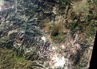 The smooth-textured area displaying a radial drainage pattern at the right-center is Jumay volcano in SE Guatemala. The volcano was constructed near the contact between Tertiary volcanic rocks on the south and Paleozoic metamorphic rocks on the north. The 2176-m-high volcano lies immediately north of the large city of Jalapa (the light-colored area at the bottom right).
NASA Landsat image, 2000 (courtesy of Loren Siebert, University of Akron).
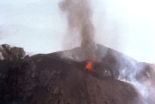 Two vents in the Fuego summit crater were active simultaneously at the time of this 24 February 1978 aerial photograph. A small ash plume rises above the vent at the far side of the crater, while the vent in the foreground ejects lava spatter. This vent feeds a degassing and faintly incandescent lava flow that can be seen to the lower right.
Photo by Bill Rose, 1978 (Michigan Technological University).
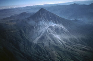 Santa María is one of Guatemala's most active volcanoes. Growth of the degassing Santiaguito lava dome complex began in 1922 at the base of the large crater formed in the Santa María SW flank during a major explosive eruption in 1902. Light-colored volcanic deposits fill the moat to the left of the dome. Lava flows accompanying dome growth descend towards the lower right. The lower peak behind and to the left of Santa María is Cerro Quemado, a lava dome complex within the Almolonga caldera.
Photo by Bill Rose, 1980 (Michigan Technological University).
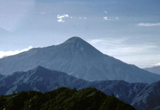 Tajumulco's southern flanks (left), which descend toward the Pacific coastal plain, are steeper than its northern flanks. At its base are exposed plutonic rocks.
Photo by Bill Rose, 1986 (Michigan Technological University).
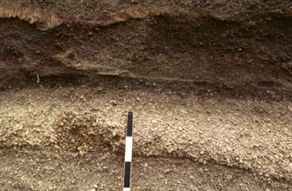 A tephra layer from Acatenango is exposed NE of the volcano along the road between Antigua and Yepocapa. Pottery fragments within the tephra layer were dated between 1,400 and 1,500 CE. Most Holocene eruptions from Acatenango originated from Pico Mayor, the southernmost and highest of the two peaks. The scale bar marks 10 cm intervals.
Photo by Bill Rose, 1978 (Michigan Technological University).
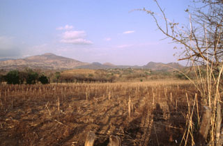 Volcán de Flores (left), one of the largest volcanoes in SE Guatemala, lies at the SW end of a cluster of small volcanic fields near the border with El Salvador. This view from the SW shows part of a chain of NW-SE-trending scoria cones across the flanks.
Photo by Giuseppina Kysar, 1999 (Smithsonian Institution).
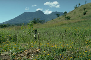 The summit lava dome complex of Tecuamburro is seen here from the NE along the road from Cuilapa. Four adjacent NW-SE-trending lava domes, the SE-most (left-center) of which is Tecuamburro proper, were erupted within a large horseshoe-shaped scar left by collapse of an ancestral edifice. These domes erupted less than 38,000 years ago. The Tecuamburro complex was constructed within a 20-km-wide graben whose northern margin terminates against the major regional Jalpatagua fault.
Photo by Lee Siebert, 1988 (Smithsonian Institution).
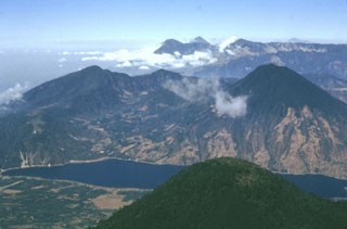 The rounded peak in the foreground is Tolimán volcano. The older post-caldera San Pedro volcano is across Santiago Bay to the right. In the distance are the peaks of Santo Tomás (left) and Santa María (right). Tajumulco volcano is the peak on the far-right horizon. The Guatemalan volcanic front rises more than 3,500 m above the hazy Pacific coastal plain to the upper left.
Photo by Bill Rose, 1980 (Michigan Technological University).
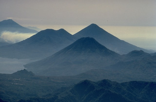 The twin volcanoes of Tolimán (left) and Atitlán (right) on the center skyline, along with San Pedro volcano in the foreground, rise above the southern shores of Lake Atitlán. This aerial view looking along the chain of stratovolcanoes stretching across Guatemala, also shows Fuego volcano at the upper left. The double-peaked Tolimán is somewhat older than the conical Atitlán volcano to its south.
Copyrighted photo by Katia and Maurice Krafft, 1983.
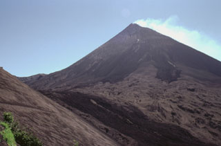 The degassing MacKenney cone at Pacaya is seen here from the NW below Cerro Chino scoria cone, whose ash-covered flank appears to the left. Darker lava flows that were erupted in 1998 descend from the summit and down the moat to the left. This flow and the two dark lobes above were erupted during the 18-19 September 1998 eruption. Lighter tephra deposits between the flows cover previous lava flows.
Photo by Paul Kimberly, 1999 (Smithsonian Institution).
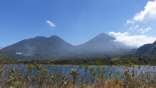 This 2018 view of Volcán Tolimán (left) and Volcán Atitlán (right) is from the shores of Lake Atitlan opposite the town of Santiago Atitlan (just out of view to the left). The cones formed along the southern rim of the Atitlán III caldera with the lake in the foreground filling the northern area.
Photo by Ailsa Naismith, 2018.
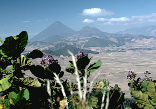 The rounded hills in the middle of the photo are part of a chain of lava domes of the Almolonga volcanic field. Partial flank collapse of an edifice sometime prior to 84,000 years ago formed a 3.3-km-wide collapse scarp that is surrounded by a ring-dike configuration of dacite and rhyolite lava domes, seen here from the east. Cerro Quemado is a young dome near the center of the horizon, right of the larger Santa María, that produced a 2.5-km-long lava flow on its eastern flank in 1818.
Photo by Lee Siebert, 1988 (Smithsonian Institution).
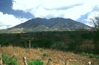 The irregular summit ridge of Volcán Suchitán is seen here from the SSW, west of the city of Asunción Mita. The edifice is extensively eroded, and large gullies descent its slopes. Two lava flows of estimated Holocene age were erupted from vents on the N and NW flanks.
Photo by Giuseppina Kysar, 1999 (Smithsonian Institution).
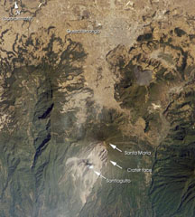 Santa María, located south of the city Quetzaltenango, is one of the country's most active volcanoes. The Santiaguito lava dome complex was constructed within a large crater formed during the 1902 eruption. The unvegetated lava flow above and to the right of Santa María was erupted from Cerro Quemado, part of the Almolonga volcanic complex, which also includes the series of lava domes to the north of Cerro Quemado. The large forested valley to the left is part of Siete Orejas volcano.
NASA International Space Station image ISS004-E-7999, 2002 (http://eol.jsc.nasa.gov/).
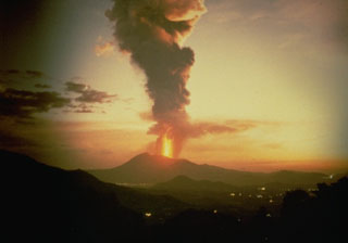 A lava fountain and ash plume rises above Pacaya, seen here in 1987 from the NW along the highway to Antigua Guatemala. Strombolian eruptions began in 1965 and were periodically interrupted by larger explosions such as this one, which deposited ash across wide areas.
Anonymous photo courtesy Norm Banks (U.S. Geological Survey), 1987.
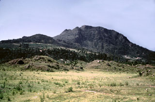 Collapse of the NE flank of the Almolonga Cerro Quemado lava dome about 1,150 years ago produced a debris avalanche deposit with the hummocky terrain in the foreground. An associated lateral blast also swept across the Llano del Pinal, the plain in the foreground. The eruption concluded with the emplacement of a small lava dome inside the avalanche scarp.
Photo by Bill Rose, 1989 (Michigan Technological University).
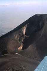 This elongate crater is along the northern flank of Pico Mayor, the summit of Acatenango. The first well-documented eruption of Acatenango took place from this N-flank vent beginning 18 December 1924. The eruption continued until 7 June 1925. On 14 March 1925 ash fell as far away as Pochuta.
Photo by Bill Rose, 1980 (Michigan Technological University).
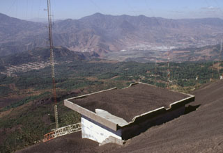 Tephra deposits from periodic larger eruptions of Pacaya coat a roof on Cerro Chino. A major eruption on 7 June 1995 caused the WNW side of Pacaya's crater to collapse, producing debris that slammed into the caldera wall at Cerro Chino, 1 km NW of the summit. A secondary hot cloud swept over Cerro Chino, destroyed a radio antenna, and affected houses within 2 km of the active vent.
Photo by Lee Siebert, 1999 (Smithsonian Institution).
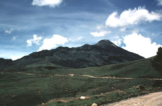 The NE side of Tajumulco volcano has gentler slopes and more extensive agricultural use than the NW side. Tajumulco lies NW of the main tourist areas in the Central Highlands and is infrequently visited. The volcano is located closer to Tacaná volcano on the México/Guatemala border than it is to other Guatemalan volcanoes.
Photo by Bill Rose, 1986 (Michigan Technological University).
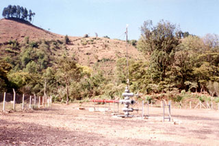 The geothermal well AMF-1 within Amatitlán caldera near Pacaya is seen here with the Laguna Caldera fault scarp in the background. Geothermal development within this 14 x 16 km Pleistocene caldera was providing electrical power to Guatemala's capital city, which overlies deposits from Amatitlán caldera.
Photo by Pat Dobson, 1997 (Lawrence Berkeley National Laboratory).
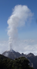 This view of El Caliente dome from the lookout point on the W flank of Santa Maria shows moderate degassing forming a vertical gas plume. The dome is part of the Santiaguito dome complex with the other domes to the right.
Photo by Ailsa Naismith, 2020.
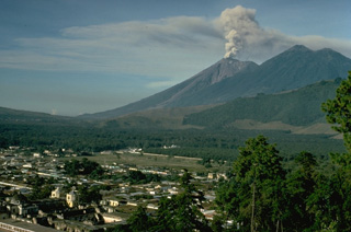 An ash column rises above the summit of Fuego volcano in early December 1974 with the city of Antigua in the foreground. This relatively minor activity took place near the end of one of Fuego's largest historical eruptions, which began in October. The twin summits of Acatenango, Pico Mayer (right) and Yepocapa (left), appear at the upper right.
Copyrighted photo by Katia and Maurice Krafft, 1974.
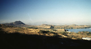 A panoramic view from the NE shows from left to right Volcán de San Diego, Cerro Masatepeque, and Loma Iguana. Laguna de Metapán is to the right. San Diego is the largest cone of a volcanic field surrounding Lake Güija on the El Salvador/Guatemala border. Lava flows from smaller vents of the San Diego volcanic field were responsible for blocking drainages and forming Laguna de Metapán, and the larger Lago de Güija was formed as a result of flows from Volcán de San Diego.
Photo by Giuseppina Kysar, 1999 (Smithsonian Institution).
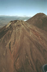 The flanks of Fuego are seen here in an aerial view from the SE in 1978 with Acatenango to the right. Over the formation of these volcanoes the activity began at the northern center, farthest away from the Central American trench (100 km S), and subsequently migrated to the south.
Photo by Bill Rose, 1978 (Michigan Technological University).
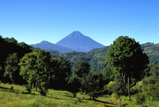 Volcán de Agua is one of Guatemala's prominent stratovolcanoes. Seen here from the north, the breached summit crater is visible.
Copyrighted photo by Stephen O'Meara, 1993.
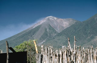 The summit of Fuego was constructed within a massive collapse scarp in the older Meseta edifice, remnants of which form the flat ridge to the right. This collapse may have happened about 8,500 years ago. The forested lower slopes of Acatenango can be seen at the right in this view from the NE.
Photo by Lee Siebert, 1988 (Smithsonian Institution).
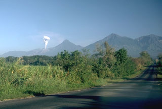 A plume rises from a Santiaguito lava dome on the flank of Santa María. Volcán Santo Tomás is the peak further to the right. A winding ridge connects Santo Tomás to Volcán de Zunil, 4.5 km to the NE, the peak at the far right.
Photo by Lee Siebert, 1988 (Smithsonian Institution).
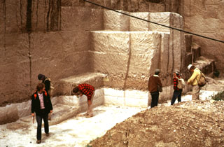 The 84,000-year-old Los Chocoyos Ash from Atitlán caldera is exposed in a quarry near San Juan Ostuncalco, west of Quetzaltenango. The white layer at the base is layer H, a rhyolite unit that is one of the largest known Plinian fall deposits in Central America. Despite its relative thinness, it is preserved over the entire Guatemalan highlands. The thicker overlying unit is the pyroclastic flow deposit, part of the Los Chocoyos ash. This massive unwelded pyroclastic flow deposit is up to 200 m thick.
Photo by Bill Rose, 1974 (Michigan Technological University).
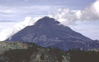 Tacaná is located on the México/Guatemala border at the far NW end of the Central American volcanic belt. It is seen here from the Guatemalan side of the border to the ENE, where it rises steeply above a 9-km-wide caldera surrounded by deeply eroded plutonic rocks. Historical activity has included mild phreatic eruptions, but stronger explosive activity and production of pyroclastic flows occurred earlier.
Photo by Bill Rose, 1986 (Michigan Technological University).
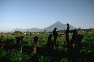 Volcán Atitlán rises above the Pacific coastal plain of Guatemala. Tolimán is the lower peak to the right of the summit. The volcanic highlands of Guatemala are seen here from the SE with Volcán Santo Tomás on the far left, 35 km to the NW of Atitlán.
Photo by Lee Siebert, 1988 (Smithsonian Institution).
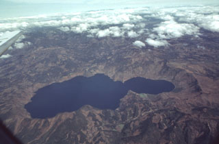 Scenic Laguna de Ayarza fills a double caldera formed during the late Pleistocene. The caldera lies about 40 km NE of the active volcanic front. The older eastern caldera (left) was associated with eruption of the Mixta pumice fall and ashflow about 27,000 years ago, and the larger western caldera was formed during eruption of the Pinos Altos airfall pumice and Tapalapa ashflows radiocarbon dated at about 23,100 years before present. Bathymetry of the lake floor shows no evidence for post-caldera eruptions.
 Photo by Bill Rose, 1982 (Michigan Technological University).
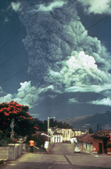 Residents of Antigua Guatemala have observed eruptions at Volcán de Fuego for several centuries. A larger ash plume towers above the city in this October 1974 view of one of Fuego's largest historical eruptions. Pyroclastic flows are also descending the east flank (left). The local topography diverted pyroclastic flows and lahars down drainages to the east and south.
Photo by Paul Newton, 1974.
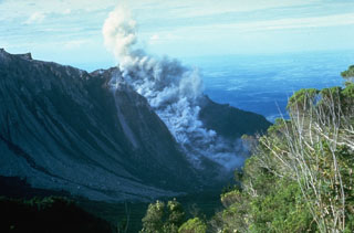 A small block-and-ash flow produced by a small collapse of the growing lava dome descends about 750 m down the north flank of El Brujo dome on 7 July 1967. The Pacific coastal plain is visible in the distance. El Brujo was the westernmost dome of the compound Santiaguito lava dome, which extends about 3 km in a roughly E-W direction.
Photo by Dick Stoiber, 1967 (Dartmouth College).
 Volcán de Agua (left) rises above the clouds west of Lake Amatitlán, located within the Amatitlán caldera. This 14 x 16 km Pleistocene caldera has produced many large explosive eruptions whose deposits underlie Guatemala City and surrounding areas. Pacaya volcano, out of view to the left, was constructed over the buried southern rim of Amatitlán caldera.
 Photo by Lee Siebert, 1988 (Smithsonian Institution).
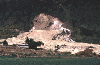 This photograph shows the source area of the 5 January 1991 Almolonga volcano Zunil geothermal field landslide. The slide damaged and buried the geothermal well ZCQ-4 within the Zunil 1 geothermal project. A small crater formed when debris that buried the well was ejected by hot water and steam that escaped from the damaged well.
Photo by Carlos Pullinger, 1993 (Servicio Nacional de Estudios Territoriales, El Salvador).
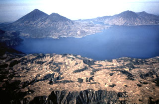 Three stratovolcanoes fill the southern half of Atitlán caldera in this view from the NE. Atitlán caldera formed during three major explosive eruptions from the Miocene to late Pleistocene. Atitlán volcano (far left) was constructed above the southern rim of the youngest caldera, Atitlán III, whose low southern rim is visible on the center horizon beyond narrow Santiago bay. Tolimán (right of Atitlán) and San Pedro (far right) overlie the rim of Atitlán II. The buried rim of Atitlán I lies below the shoreline of Tolimán.
Photo by Bill Rose, 1980 (Michigan Technological University).
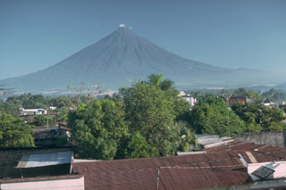 Volcán de Agua rises above the city of Escuintla, which underlies a massive debris avalanche deposit from the Fuego-Acatenango massif, out of view to the left.
 Photo by Lee Siebert, 1988 (Smithsonian Institution).
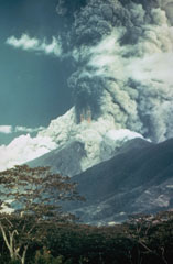 A large ash plume towers above Fuego in October 1974 as pyroclastic flows sweep down the SE (left) and NE flanks (center). Incandescent ejecta can be seen at the base of the ash plume. Prevailing winds distributed ashfall primarily to the SW. More than 0.2 km3 of ash was erupted during four distinct explosive pulses of 4 to 17 hours duration between 14 and 23 October.
Photo by William Buell, 1974.
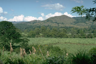 The Cuilapa-Barbarena volcanic field contains approximately 70 Quaternary scoria cones, generally less than 100 m high. Many of the cones are located along the Jalpatagua fault, which extends SE from Guatemala City, north of the chain of volcanoes extending across Guatemala. The youngest cones were estimated to be of Holocene age, perhaps less than 1,000 years old.
Photo by Lee Siebert (Smithsonian Institution).
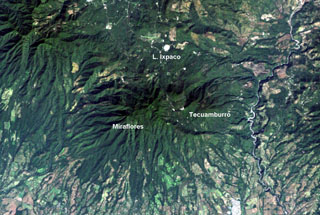 The Tecuamburro volcanic complex has a diverse history. Collapse of the ancestral Pleistocene Miraflores edifice underwent collapse, producing an avalanche deposit that traveled across the Río los Esclavos (right) and forming a large horseshoe-shaped crater open to the east. The modern Tecuamburro complex, consisting of four lava domes, was constructed within this scarp. The Laguna Ixpaco crater was created about 2,900 years ago within the much larger Pleistocene Chupadero crater.
NASA Landsat image, 2000 (courtesy of Loren Siebert, University of Akron).
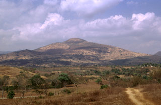 Volcán de Flores, seen here from the SSW, is one of the largest of a cluster of small volcanoes located behind the main volcanic front in SE Guatemala. The summit rises up to 600 m above a basement of Cretaceous and Tertiary sedimentary rocks and contains a smaller summit cone with a shallow crater that opens to the east. An alignment of scoria cones trends across the flanks.
Photo by Francesco Frugioni, 1999 (Istituto Nazionale di Geofisca e Vulcanologia, Rome).
 A volcanic plume from Pacaya volcano extends eastward from the left to Cerro Redondo, a small symmetrical cinder cone in the center of the image. This cone is one of the youngest features of the Cuilapa-Barbarena volcanic field, a cluster of about 70 Quaternary cinder cones located near the cities of Cuilapa and Barbarena (lower right) and in areas to the north and west. The cones were constructed where the NW-SE-trending Jalpatagua Fault intersects the southern margin of the Miocene Santa Rosa de Lima caldera.
NASA Landsat image, 2000 (courtesy of Loren Siebert, University of Akron).
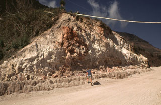 The rock around the Almolonga volcano Zunil geothermal field on the SE flank of Cerro Quemado volcano is extensively hydrothermally altered. The geothermal area is located along the Zunil fault zone, which juxtaposes brownish-red weathered to lightly altered andesite to dacite lava flows with white-to-pink heavily altered and brecciated volcanic rock. Hydrothermal alteration minerals include kaolinite, pyrite, gypsum, and alunite. The NE-SW-trending left-lateral fault zone runs parallel to the valley of the Río Samalá.
Photo by Bill Rose, 1981 (Michigan Technological University).
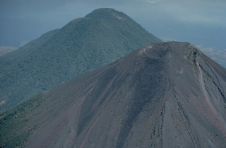 Atitlán (foreground) and Tolimán are twin volcanoes located immediately south of Lake Atitlán (background). Tolimán was constructed on the buried rim of the Atitlán II caldera, whereas Volcán Atitlán was built 4 km south over the rim of the Atitlán III caldera. Atitlán, whose summit area remains unvegetated, has been active in historical time. Tolimán has not had historical eruptions, but has erupted within the past 1000 years.
Copyrighted photo by Katia and Maurice Krafft, 1983.
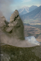 An explosion from MacKenney crater on Pacaya volcano ejects a dark, ash-rich column and individual blocks that are sometimes incandescent even during daylight hours. This December 1974 photo shows Fuego (left) and Acatenango (right) volcanoes in the background, behind the sloping flanks of Agua volcano.
Copyrighted photo by Katia and Maurice Krafft, 1974.
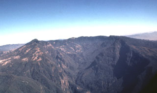 The massive breached caldera of Siete Orejas volcano is seen here from the south, the direction in which it is breached by the Ocosito river. Irregularities on the broad rim of the 3.5 x 10 km caldera give the volcano its name, which means "Seven Ears."
 Photo by Bill Rose, 1980 (Michigan Technological University).
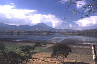 The largest peak on the El Salvador/Guatemala border is Volcán Chingo, seen here from the SW on the shores of Laguna de Llano on the Salvador side of the border.
Photo by Giuseppina Kysar, 1999 (Smithsonian Institution).
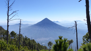 Volcán de Agua is seen here from the E flank of Volcán Acatenango. The peaks of Cerro Grande and Volcán Pacaya are visible behind Agua (right) and the town of Alotenango is below it.
Photo by Ailsa Naismith, 2020.
 Santa María is one of the most active volcanoes in Guatemala. Its morphology changed drastically in 1902 when a catastrophic eruption formed a 1-km-wide crater. The large Santiaguito lava-dome complex (center) has been growing at the base of the 1902 crater since 1922. Lava flows can be seen down the flank. Dome growth is accompanied by frequent minor explosions, along with periodic lava extrusion, larger explosions, pyroclastic flows, and lahars.
Photo by Bill Rose, 1980 (Michigan Technological University).
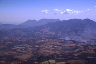 The deeply eroded Plio-Pleistocene stratovolcano at the upper right is Pueblo Nuevo Viñas (also known as Cerro la Gabia). Four scoria cones are located on the NE flank, and lava flows from the volcano cover the western portion of the Cuilapa quadrangle. This view is from the NW at the summit of Pacaya volcano with Tecuamburro volcano on the center horizon. Flank activity from Tecuamburro has occurred as recently as about 3,000 years ago.
Photo by Lee Siebert, 1999 (Smithsonian Institution).
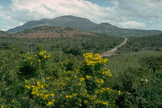 Ipala is part of a cluster of closely spaced small stratovolcanoes and scoria cone fields in SE Guatemala. The summit has a 1-km-wide crater containing a lake. The eastern flank, seen here from the SW, contains a line of Holocene scoria cones and lava flows. Monte Rico is the scoria cone on the south flank (right).
 Photo by Lee Siebert, 1993 (Smithsonian Institution).
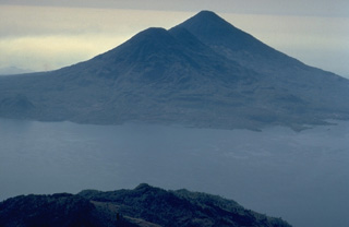 The twin volcanoes of Tolimán and Atitlán rise above the southern shores of Lake Atitlán in this view from the NNW. The surface of Tolimán (left) is draped by prominent thick lava flows. Many of the flows were erupted from vents on the volcano's flanks and form an irregular shoreline on the south side of Lake Atitlán. A lava flow from the parasitic lava dome of Cerro de Oro on the north flank entered Lake Atitlán and is less than a few thousand years old. No historical eruptions are known from Tolimán.
Copyrighted photo by Katia and Maurice Krafft, 1983.
 The 80-m-high headwall scarp of the 5 January 1991 landslide at the Almolonga volcano Zunil geothermal field exposes the regional Zunil fault zone. The avalanche deposit extends about 800 m from the source and damaged the highway between Quetzaltenango and the town of Retalhuleu on the Pacific coastal plain. The avalanche destroyed a church and more than a half-dozen houses, killing 23 people. The elevation difference from the head of the scarp to the distal end of the deposit was 250 m.
Photo by Lee Siebert, 1993 (Smithsonian Institution).
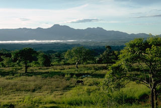 The highest peak in this view is Moyuta and is one of the easternmost of a chain of volcanoes extending across Guatemala. Its flat-topped summit is formed by a cluster of lava domes. The volcano lies south of the NW-SE-trending Jalpatagua Fault and overtops the southern margin of the Jalpatagua Graben.
Photo by Lee Siebert, 1988 (Smithsonian Institution).
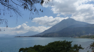 This 2018 view of Volcán San Pedro of Guatemala is from the W near San Juan La Laguna, with Volcán Tolimán volcano behind it. These cones along with the active Atitlán cone behind them have formed along the rim of the Atitlán III caldera, with the lake in the foreground filling the northern area.
 Photo by Ailsa Naismith, 2018.
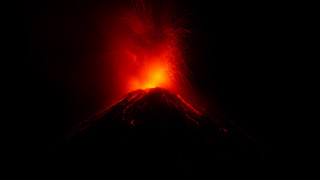 Incandescent bombs ejected from Fuego’s summit vent impact the upper flanks on 20 February 2020. The ballistic trajectories are visible at night with initial velocities reaching several hundred meters per second. This photo is taken from Observatorio del Volcán de Fuego (OVFGO), Panimaché Uno, Chimaltenango, below the SW flank.
Photo by Ailsa Naismith, 2020.
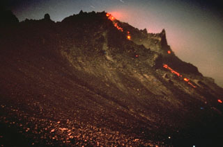 Incandescence is visible at the top of the growing Santiaguito lava dome in Guatemala. Rockfalls of hot material produce a visible trail down its northern flank. The dome began growing in 1922 in a large crater formed on the SW flank of Santa María volcano during a powerful explosive eruption in 1902. Dome growth has been continuous since 1922 and has produced a composite dome over 3 km long. This photo of El Brujo, the westernmost vent, was taken on 12 November 1967.
Photo by Charles Pineo, 1967 (Dartmouth College, courtesy of Dick Stoiber).
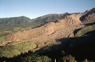 The thick unvegetated lava flow descending diagonally across the photo originated from El Brujo (upper right) at the western end of the Santiaguito lava dome complex. This north-looking 1970 view shows Santiaguito's SW-flank topography prior to a period of rapid lava extrusion from El Brujo during 1972-75. The flanks of Siete Orejas volcano form the horizon.
Photo by Bill Rose, 1970 (Michigan Technological University).
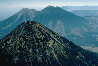 The forested summit of symmetrical Agua volcano appears in the foreground with the twin volcanoes of Fuego (left) and Acatenango (right) in the background. The three stratovolcanoes overlook the historical city of Antigua Guatemala, whose outskirts appear on the right. Agua has had no historical eruptions, in contrast to Acatenango and especially Fuego, which is one of the most active volcanoes of Guatemala. This 1983 aerial view is from the west.
Copyrighted photo by Katia and Maurice Krafft, 1983.
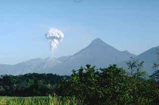 An ash plume rises above the Santiaguito lava dome in March 1988. Explosive eruptions such as these are typical of the growing lava dome since activity began in 1922. The dome was constructed at the base of a large crater, seen here in profile from the Pacific coastal plain to the SE. The crater formed low on the SW flank and extended almost to the summit.
Photo by Lee Siebert, 1988 (Smithsonian Institution).
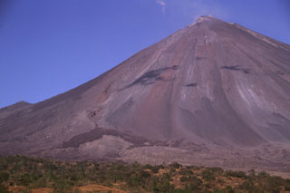 Frequent eruptions from MacKenney crater at Pacaya have kept the flanks free of vegetation. The summit towers more than 1 km above its base. The darker area to the lower left in this February 1999 photo is a September 1998 lava flow that originated from a vent on the lower SW flank that bifurcated into lobes that traveled to the SW and S. The lighter area below the flow extending to the right margin of the photo is a debris avalanche deposit that formed when the summit crater rim collapsed.
Photo by Lee Siebert, 1999 (Smithsonian Institution).
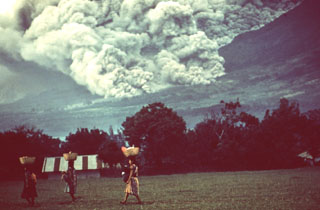 Pyroclastic flows occurred frequently during the October 1974 eruption, and residents of nearby fincas (farms) are seen here carrying goods across a field in front of the pyroclastic flow descending the eastern flank behind them. Despite the frequency and magnitude of the pyroclastic flows, they affected relatively sparsely populated flanks of the volcano and produced no fatalities.
Photo by William Buell, 1974.
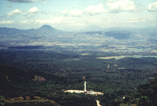 This view from the Apaneca Range shows the CH-A well and drill rig of the Ahuachapán geothermal field in the foreground. The peak on the left horizon across the lowlands of El Salvador's interior valley is Volcán Chingo, along the El Salvador/Guatemala border. The flatter peak to the far right is Volcán Suchitán in Guatemala.
Photo by Comisión Ejecutiva Hidroeléctricia del Río Lempa (CEL), 1992.
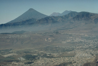 The beautifully symmetrical Agua volcano forms a prominent backdrop to Guatemala City in the foreground. The twin volcanoes of Fuego (left) and Acatenango (right) appear to the right of Agua in this 1983 view from the NE. No historical eruptions are known of Agua volcano, despite its youthful profile.
Copyrighted photo by Katia and Maurice Krafft, 1983.
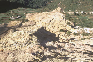 This view looks down the path of the 5 January 1991 landslide at the Almolonga volcano Zunil geothermal site. The avalanche of extensively hydrothermally altered material along the Zunil fault zone traveled 800 m from its source. The slide nearly reached the Río Samala and can be seen at the top of the photo cutting the highway between Quetzaltenango and Retalhuleu. The deposit has four overlapping lobes with a combined thickness of 2-3 m.
Photo by Claus Siebe, (Universidad Nacional Autónoma de México).
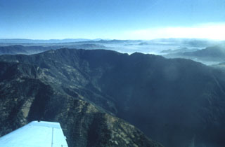 The southern side of Siete Orejas volcano is cut by a large breached caldera drained by the Ocosito river. The caldera, seen here from the SW, is 3.5 km wide and more than 10 km long, and its walls tower about 1000 m above the caldera floor. The origin of the caldera is uncertain, but may involve one or more processes including collapse following a major explosive eruption, collapse by slope failure, and excavation by headward stream erosion.
Photo by Bill Rose, 1980 (Michigan Technological University).
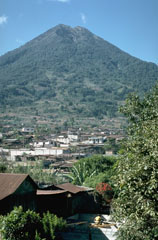 Volcán de Agua towers above the town of Santa María de Jesús on its NE flank. A scarp on the upper north flank extending from the summit crater was the source of a major debris flow in 1541 that destroyed towns on the NW flank. This catastrophe was not accompanied by an eruption.
Photo by Lee Siebert, 1988 (Smithsonian Institution).
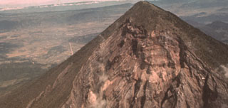 The catastrophic 1902 Santa María eruption formed a massive 1.5-km-wide crater in the SW flank. The upper part of the crater wall, which extends nearly to the summit of Santa María, is seen here from the SW. Guatemala's second largest city, Quetzaltenango, lies in the basin visible to the left, 10 km to the NNE. The 1902 eruption took place after a long period of quiescence that followed construction of the edifice.
Photo by Sam Bonis (Instituto Geográfico Nacional).
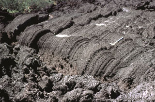 This lava flow surface were formed when still-fluid lava was squeezed through an irregular crack in previously solidified crust. Note the rock hammer at the right-center for scale. Frequent lava extrusion has occurred at Pacaya since 1965.
Photo by Bill Rose, 1978 (Michigan Technological University).
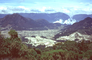 The Cerro Quemado lava dome (left), seen here from Siete Orejas volcano, is one of a series of lava domes along the margin of the Almolonga caldera. The Cerro Quemado dome complex formed during the Holocene from eruptions along at least eight vents. One of these domes forms the low rounded feature below the center horizon. Santa María lies just out of view to the right, and the western side of the Santo Tomás volcanic complex forms the horizon.
Photo by Bill Rose, 1975 (Michigan Technological University).
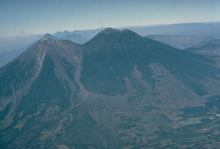 The paired volcanoes of Fuego (left) and Acatenango, seen here in profile from the ESE, illustrate the N-S progression of volcanism that is typical of paired volcanoes in Guatemala and México. Activity at Yepocapa (right), the lower northern summit of Acatenango, ended about 20,000 years ago, after which Acatenango's highest cone, Pico Mayor, was built. Activity then again migrated southward to build Meseta volcano, a remnant of which forms the shoulder left of the saddle between Acatenango and Fuego. Lastly, modern Fuego was constructed south of Meseta volcano.
Copyrighted photo by Katia and Maurice Krafft, 1983.
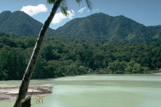 Ixpaco crater is a 1-km-wide maar on the NW flank of Tecuamburro that formed during an explosive eruption about 2,900 years ago. An acidic lake fills the maar, and fumaroles, acid-sulfate hot springs, and mud pools occur around the lake. Colloidal sulfur turns the lake a milky green color. This view is from the north with the forested lava domes of Cerro Miraflores (left) and Cerro Pena Blanca (right) in the background.
Photo by Lee Siebert, 1988 (Smithsonian Institution).
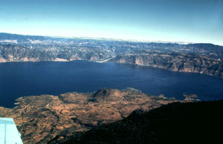 Lake Atitlán fills the northern half of the Atitlán III caldera, which formed about 84,000 years ago following eruption of the Los Chocoyos Ash. The 18-km-long caldera lake is seen here from the south, with the flanks of the post-caldera Tolimán volcano in the foreground. The relatively flat lake floor is 300 m below the water surface, and caldera walls rise to about 1 km above the lake.
 Photo by Bill Rose, 1980 (Michigan Technological University).
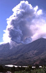 An eruptive episode at Fuego began on 4 January 2002 and continued intermittently into 2003. This 8 January 2002 image taken from the east shows an ash plume. Effusion of lava flows down the east flank began in late January 2002. On 2 August 2002 explosive activity changed from Strombolian to Vulcanian.
Photo by Sid Halsor, 2002 (Wilkes University).
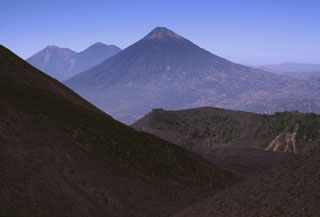 Volcán de Agua is in the center of this photo and lava flows from MacKenney cone form the slope in the foreground. They have filled in the moat of the Pacaya caldera almost to the level of the lower Cerro Chino crater rim, with the communication antennas along the summit in the midground. The two volcanoes on the left horizon are Fuego (left), one of the most active in Guatemala, and Acatenango (right).
Photo by Lee Siebert, 1999 (Smithsonian Institution).
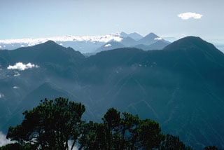 Volcán Santo Tomás is a Pleistocene stratovolcano, seen here from the summit of Santa María volcano to its NW. Geothermal activity occurs 3 km N and NW of the Volcán Zunil summit (right), which is located at the southern end of the volcanic complex. The Tolimán-Atitlán and Acatenango-Fuego complexes appear in the distance.
Photo by Lee Siebert, 1993 (Smithsonian Institution).
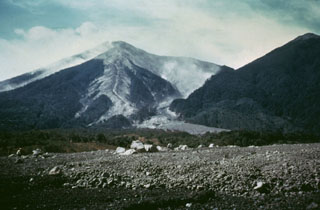 Hot pyroclastic flow deposits from the 1974 eruptions fill barrancas on the eastern flanks of Fuego. The deposit was the northeastern-most produced during the eruptions. Large blocks in the foreground were emplaced near the terminus of the deposit. The light-colored pyroclastic deposits extending from the summit are confined within levees with broader surge deposits that overtopped them.
Photo by Greg Hahn, 1974 (courtesy of Bill Rose, Michigan Technological University).
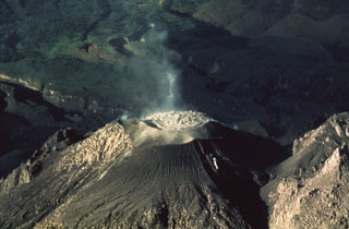 A lava dome fills the crater of the Caliente vent of a Santiaguito lava dome in 1988, as seen from the summit of Santa María. Slow dome growth was accompanied by periodic explosions that ejected ash plumes to about 1.5 km above the vent.
Photo by Jon Fink, Arizona State University, 1988 (courtesy of Bill Rose, Michigan Technological University).
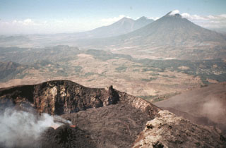 The Pacaya MacKenney crater contains spatter cones that have produced lava flows, and gas plumes like the one seen here. This photo taken in May 1981 shows the broad several-hundred-meter wide crater rim. From 9 May to 2 June lava flows from the spatter cones covered the crater floor and flowed through notch in the NW crater rim. In the background are Fuego and Acatenango (right-center) and Volcán de Agua (right).
 Photo by Bill Rose, 1981 (Michigan Technological University).
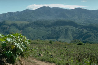 The western side of the low-angle, eroded Ixhuatán volcanic complex rises beyond the Río Los Esclavos as seen from the flank of Tecuamburro volcano. The 1718-m-high dominantly andesitic volcano is of Pliocene-Pleistocene age. The youngest center is a dacitic lava-dome complex at Cerro los Achiotes. The domes and associated ashfall and ashflow deposits partially fill and extend from a horseshoe-shaped caldera that is breached to the SE and may have formed as a result of slope failure.
 Photo by Lee Siebert, 1988 (Smithsonian Institution).
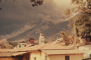 Pyroclastic flows descend the Barranca Honda and an adjacent drainage on the eastern flank of Fuego volcano in February 1973. Following strong steam emissions on 22 February 1973 small eruptions beginning 23 February were accompanied by pyroclastic flows down the Barranca Honda. Explosive eruptions continued until 3 March and resumed 13 and 22-23 March. This photo was taken from Finca Capetillo, near Alotenango.
 Photo by Sam Bonis, 1973 (courtesy of Bill Rose, Michigan Technological University).
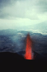 Incandescent lava rises from MacKenney crater early in the 1965-89 Pacaya eruption. The date of the photo is not certain but may have been around 1967. This view looks west from the summit of MacKenney cone with the flank of Volcán de Agua in the distance.
Photo by Alfredo MacKenney (courtesy of Bill Rose, Michigan Technological University).
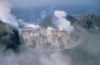 A lava dome fills Caliente crater at the eastern end of the Santiaguito dome complex in June 1968. Gases rise from fumaroles along the margins of the roughly 100-m-wide crater in this view from the north. Periodic ash eruptions accompanied growth of the dome. The Caliente vent is in the oldest part of the Santiaguito dome complex, which began erupting in 1922. It was the source of a major explosive eruption in 1929 that produced large pyroclastic flows.
Photo by Dick Stoiber, 1968 (Dartmouth College).
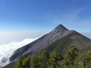 Fuego is seen here from Volcán Acatenango in February 2017. The ridge to the right of Fuego’s summit is a remnant of the older La Meseta edifice that underwent collapse approximately 9,000 years ago. The Barrancas Hondas and Las Lajas ravines that channel pyroclastic flows and lahars are visible on Fuego’s eastern flanks (left side); Honda is closer and deeper, with areas of red oxidation.
Photo by Ailsa Naismith, 2017.
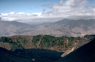 Cerro Chino produced a major eruption in 1775. This eruption began at vents on the SW flank (behind the crater in this view) and then migrated towards the summit. Powerful lava fountains were observed and ashfall was reported up to 200 km away. Recent lava flows are in the foreground.
Photo by Lee Siebert, 1988 (Smithsonian Institution).
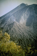 The cone in the center grew on the NE flank of MacKenney cone (background) during a long-term eruption that began in 1965. This small NE-flank vent was active from 5 August 1984 until 6 February 1985 and produced a 50-m-high cone that sent sinuous lava flows its flanks. Later eruptions buried most of the cone before it was destroyed by an explosion in 1995. This 1985 photo was taken by Alfredo MacKenney, the Guatemala City physician and volcano enthusiast for whom the cone was named.
Photo by Alfredo MacKenney, 1985.
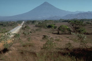 Volcán de Agua towers above the Pacific coastal plain to its south. The foreground surface is part of the massive Escuintla debris avalanche deposit most likely produced by collapse of the Acatenango-Fuego massif out of view to the left.
Photo by Jim Vallance, 1989 (Michigan Technological University).
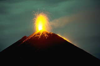 A period of Strombolian activity began at Pacaya in 1965 and continued for over 25 years. Nighttime explosions are often visible from Guatemala City, 40 km N. The accumulation of ejecta from frequent explosions periodically increases the height of MacKenney cone after it has been partially destroyed by intermittent larger explosions. This November 1988 photo also shows a lava flow descending the west flank (right).
Photo by Lee Siebert, 1988 (Smithsonian Institution).
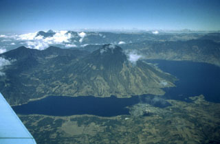 Volcán San Pedro (center) occupies the SW corner of the roughly 85,000-year-old Atitlán III caldera. San Pedro is seen here across narrow Santiago Bay from the lower slopes of Atitlán and Tolimán volcanoes. The 3020-m-high San Pedro has a shallow summit crater that is breached to the NW. The age of the most recent activity of San Pedro is unknown, although the volcano is more vegetated and erosionally modified than the twin volcanoes of Tolimán and Atitlán and is clearly the oldest of the three post-caldera volcanoes.
Photo by Bill Rose, 1980 (Michigan Technological University).
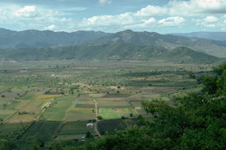 Retana caldera, between Suchitán and Tahual volcanoes, was once filled by Laguna Retana. The lake periodically became dry and was refilled in the 19th and 20th centuries and has now been drained to access the rich soils on the lake floor. A canal drains the lake through a notch on its northern rim (far right). The caldera is seen here from its eastern rim, on the flank of Suchitán. Volcán Tahual is the forested volcano just behind the caldera wall and to the right.
Photo by Lee Siebert, 1993 (Smithsonian Institution).
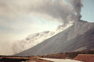 A pyroclastic flow descending the east flank of Fuego on 8 January 1979, is viewed from the city of Antigua Guatemala to the NE. Intermittent explosive eruptions had been occurring since September 1977 and lasted until 8 August 1979.
Photo by Paulino Alquijay, 1979 (courtesy of Pete Newton).
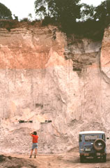 A geologist examines an outcrop of the 84,000-year-old Los Chocoyos Ash near Patzún, about 10 km E of Lake Atitlán. Note the charred log above his head. This pyroclastic flow unit of the Los Chocoyos deposit is up to 200 m thick and is exposed over an area of about 2,000 km2. Individual flow units of the voluminous ignimbrite are sometimes more than 100 m thick. The upper part of the deposit is characteristically salmon-pink in color as a result of oxidation of the cooling flow.
Photo by Bill Rose, 1980 (Michigan Technological University).
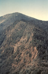 This view looks to the south from near the summit of Volcán de Zunil towards Volcán Santo Tomás. Geothermal fields are located along the ridge between Santo Tomás and Zunil.
 Photo by Bill Rose, 1977(Michigan Technological University).
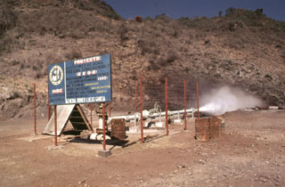 The Almolonga volcano Zunil geothermal project is seen here in 1981, a decade prior to a landslide that buried the well site. Well ZCQ-4 was drilled in 1981 to a depth of about 1.3 km and cemented to a depth of 400 m. In October 1989 the recorded bottom hole temperature was 260°C. The upper part of the geothermal system contains acid-sulfate hot springs. Associated mud pools and fumaroles occur at high points on both sides of the Río Samalá, and bicarbonate-rich hot springs discharge into the river's canyon.
Photo by Bill Rose, 1981 (Michigan Technological University).
 The Volcán de Pacaya massif rises above the capital city of Guatemala, located only 30 km to the north. The rounded, forested lava dome of Cerro Grande forms the high point at the left. The next highest peak to the right is the historically active vent of Pacaya, with the right-hand summit being the MacKenney cone, which has been active since 1965. Eruptions of Pacaya are often visible from Guatemala City.
Photo by Bill Rose, 1989 (Michigan Technological University).
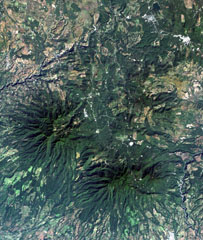 The top-center portion of this Landsat image consists of topographically indistinct Piedra Grande, a cluster of faulted, heavily eroded andesitic stratovolcanoes. The Piedra Grande complex lies between the NW-trending Jalpatagua Fault, which cuts diagonally through the city of Barbarena (the small white area at the upper right), and Tecuamburro volcano (lower right). The vent area of Piedra Grande lies within 4-km-wide, nested depressions open to the east, NE of the more prominent forested Puebla Nuevo Viñas volcano (left center).
 NASA Landsat image, 2000 (courtesy of Loren Siebert, University of Akron).
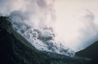 A pyroclastic flow produced by collapse of a growing lava dome descends the northern flank of the Santiaguito lava dome in November 1967. Periodic larger collapses of Santiaguito have sent pyroclastic flows down the populated southern flanks. The most catastrophic of these traveled 10 km in 1929, when hundreds to thousands of people were killed.
 Photo by Dick Stoiber, 1967 (Dartmouth College).
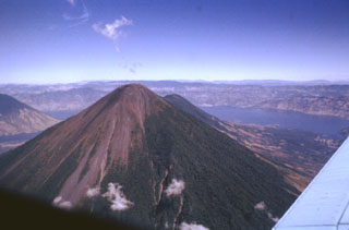 Volcán Atitlán directly overlies the inferred margin of the Pleistocene Atitlán III caldera, whose northern rim lies across Lake Atitlán. The Atitlán stratovolcano is adjacent to Tolimán to its north (seen just to the right of Atitlán's summit). The historically active Atitlán is younger than Tolimán, although their earlier activity overlapped. Atitlán’s surface is composed of tephra, reflecting its predominantly explosive eruptions that have been recorded since the 15th century.
Photo by Bill Rose, 1980 (Michigan Technological University).
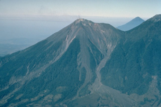 Volcán Fuego, one of Central America's most active volcanoes, is one of three large stratovolcanoes overlooking Guatemala's former capital, Antigua. The scarp of an older edifice, Meseta, forms the shoulder between between Fuego and its twin volcano, Acatenango. This view from the SE also shows Atitlán volcano above the saddle between Fuego and Acantenango. Vigorous historical eruptions have been recorded at Fuego since 1524. They have produced major ashfalls, along with occasional pyroclastic flows and lava flows.
 Copyrighted photo by Katia and Maurice Krafft, 1983.
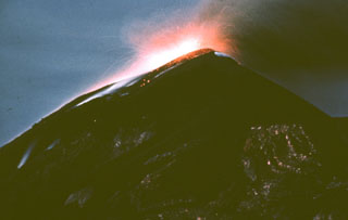 A nighttime exposure shows incandescent ejecta at the Fuego summit in 1962. Explosive activity and lava effusion took place during 4-20 August 1962. The August eruptions also produced pyroclastic flows. Eruptive activity resumed in October prior to a large explosive eruption on 9 November that produced a 12-km-high ash plume. During the November eruption much of the crater was filled with ejecta.
Photo by Alfredo MacKenney, 1962 (courtesy of Bill Rose, Michigan Technological University).
 Volcán Chingo, located along the Guatemala/El Salvador border, is the second highest of a group of volcanoes in SE Guatemala. It is seen here from the Guatemalan side above Laguna Atescatempo, which was created when lava flows from the Volcán Chingo area dammed local drainages. Many basaltic scoria cones are located on the flanks on both sides of the border.
Photo by Lee Siebert, 1993 (Smithsonian Institution).
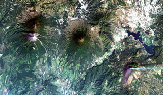 Guatemala's capital city (upper right) is flanked by four major stratovolcanoes and a large caldera. Steaming Pacaya volcano (lower right) was constructed near the southern rim of the partially lake-filled Amatitlán caldera, whose major late-Pleistocene silicic eruptions have produced thick pyroclastic-flow deposits exposed around Guatemala City. Conical Agua volcano (center) is a prominent landmark from the city, and the paired volcanoes of Acatenango and Fuego (left) lie to the west.
NASA Landsat image, 2000 (courtesy of Loren Siebert, University of Akron).
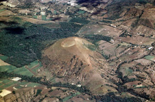 Cerro La Olla is one of a chain of young scoria cones erupted on either side of Volcán Chingo. The southern vents, including Cerro La Olla, lie in El Salvador, while the northern vents, the largest of which is Volcán Las Viboras, are in Guatemala.
Photo by Paul Kimberly, 1999 (Smithsonian Institution).
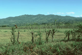 The eroded Plio-Pleistocene Ixhuatán volcano rises to the NE above the Pacific coastal plain of Guatemala. Ixhuatán has produced dominantly andesitic lava flows and volcaniclastic deposits. NE-SW-trending faults cut the volcanic complex. Pleistocene andesitic ignimbrite deposits from the neighboring Tecuamburro volcanic complex bank up onto the western flanks of Ixhuatán.
Photo by Lee Siebert, 1988 (Smithsonian Institution).
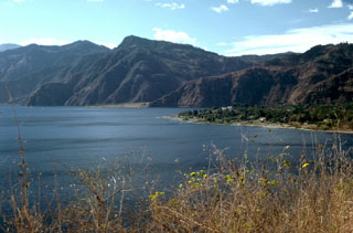 The resort town of Panajachel occupies a delta of the river of the same name that flows into Lake Atitlán, within the Atitlan caldera. The northern caldera wall rises about 1 km above the lake surface. The level of the lake has fluctuated more than 10 m over periods of several decades, and titles exist to land now submerged hundreds of meters from the current shoreline. High heat flow is present in the lake.
Photo by Lee Siebert, 1988 (Smithsonian Institution).
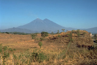 The hummocky surface in the foreground in front of the Fuego and Acatenango volcanoes in Guatemala is a massive debris-avalanche deposit in Escuintla that was produced by partial collapse of the volcanic complex sometime during the late Pleistocene to early Holocene. This is the largest known debris avalanche in Guatemala; it has an estimated volume of about 15 km3 and traveled about 50 km. For the last 30 km, the avalanche traveled over flat slopes of less than 1 degree, illustrating the extremely high mobility of volcanic debris avalanches.
Photo by Jim Vallance, 1989 (Michigan Technological University).
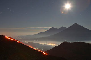 This time-lapse night view of Pacaya's MacKenney cone is looking towards the W in December 2007. The lower-relief Cerro Chino of the Pacaya complex in the right foreground, and in the background from right to left are Volcán de Agua, Acatenango, and Fuego.
Photo courtesy of Richard Roscoe (www.photovolcanic.com).
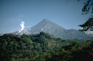 Three distinct stages marked the growth of Santa María. The large edifice formed over a basement of older volcanic and plutonic rocks beginning about 30,000 years ago and ending about 500 to several thousand years ago. A massive eruption in 1902 then created the large crater on the SW flank seen in the shadow left of the summit. The third stage is marked by continued growth of the Santiaguito lava dome complex (left) in the new crater since 1922.
Photo by Lee Siebert, 1988 (Smithsonian Institution).
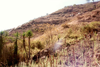 Steam rises from fumaroles at Laguna Caldera, within Amatitlán caldera near Pacaya. In addition to the fumaroles seen here near the southern margin of the caldera, hot springs are located at several places along the shore of Lake Amatitlán in the center of the caldera. This largely Pleistocene caldera has been the site of geothermal exploration because of the high heat flow in the system.
Photo by Pat Dobson, 1997 (Lawrence Berkeley National Laboratory).
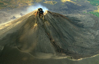 The degassing MacKenney cone summit crater of Pacaya is shown in this February 1999 aerial view from the north. A trail in the foreground is along the rim of a large horseshoe-shaped crater inside which the cone was constructed. Lava flows from the summit crater and flank vents of MacKenney cone have traveled into the moat and subsequently been deflected to the west and south.
Copyrighted photo by Stephen and Donna O'Meara, 1999.
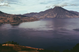 Volcán San Pedro (upper right) is the oldest of three stratovolcanoes constructed within Atitlán caldera. The furrowed slopes of the volcano contrast with the less eroded flanks of the both Atitlán and Tolimán volcanoes. Cerro de Oro, the small lava dome just beyond the shore of Lake Atitlán to the left, is a flank dome of Tolimán. Young lava flows from Tolimán descend into the lake and form part of its southern shore in this view from the west.
Photo by Bill Rose, 1978 (Michigan Technological University).
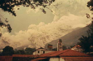 A pyroclastic flow descends drainages on the east flank of Fuego in October 1975 as an ash plume (right) towers above the summit. Intermittent minor eruptions took place 28 May, 23 July to 4 August, and 19 September to 21 October 1975. On 11-12 and 16 October ash fell in, and west of, Antigua. This photo was taken from Finca Capetillo, near Alotenango. Pyroclastic flows frequently travel down these same drainages and had occurred during the two previous eruptions in 1973 and 1974.
 Photo by Bill Rose, 1975 (Michigan Technological University).
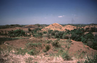 Hummocks of the Escuintla debris avalanche deposit, most likely from the Fuego-Acatenango massif, cover the Pacific coastal plain of Guatemala about 30 km from their source. This massive volcanic landslide is the largest known in Guatemala. The avalanche traveled about 50 km from the Fuego-Acatenango massif and covered about 420 km2, with an estimated volume of about 15 km3.
Photo by Bill Rose, 1988 (Michigan Technological University).
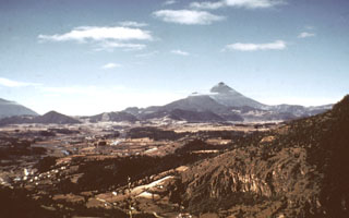 The line of low-elevation forested lava domes in the center of the photo are a chain of domes erupted along the rim of a Pleistocene caldera of the Almolonga complex. The highest dome, Cerro Quemado, is the peak seen here from the north below and to the left of Santa María, the highest peak in this photo. A 3.3-km-wide caldera formed within the field sometime prior to 85,000 years ago. Post-caldera eruptions produced eight lava domes.
Photo by Bill Rose, 1973 (Michigan Technological University).
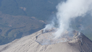 This 28 February 2017 photograph of El Caliente dome summit shows that the dome had nearly filled the crater. Pyroclastic flows from El Caliente are often caused by the partial collapse of an overflowing dome. Weak degassing is visible from the center and perimeter of the dome. Blocky lava flows produced from El Caliente vent are visible in the background.
Photo by Ailsa Naismith, 2017.
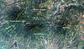 Four large Pleistocene volcanic complexes are visible in this Landsat image of southern Guatemala, with the Pacific coastal plain at the bottom. Minor activity at Tecuamburro volcano continued into the Holocene at Laguna Ixpaco, the small circular white dot a little more than half-way between the Tecuamburro and Piedra Grande labels. The Río los Esclavos extends from the upper right, cutting between Tecuamburro and Ixhuatán volcanoes.
NASA Landsat image, 2000 (courtesy of Loren Siebert, University of Akron).
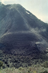 This lava flow descended the northern flank of El Brujo on Santiaguito. El Brujo, seen here from the La Loma trail, is the westernmost of the Santiaguito lava dome complex that began erupting in the late 1950s.
Photo by Bill Rose, 1972 (Michigan Technological University).
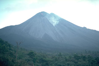 An ash plume generated by collapse of a lava flow front is seen on the SW flank of Pacaya in November 1988. Frequent Strombolian eruptions began at MacKenney cone in 1965 and were often accompanied by lava flows from summit or flank vents, which have traveled out to 6 km down the southern flank.
Photo by Lee Siebert, 1988 (Smithsonian Institution).
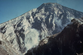 The interior of a stratovolcano is dramatically revealed in a 1-km-wide crater created on the SW flank of Guatemala's Santa María volcano during an eruption in 1902. The 1,200-m-high scarp exposes thin, light-colored lava flows that are interbedded with deposits of fragmented rock produced during growth of the volcano. The 1902 eruption was one of the world's largest during the 20th century.
Photo by Dick Stoiber, 1969 (Dartmouth College).
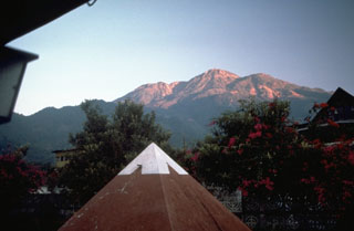 Tacaná is located along the México/Guatemala border, seen here from the SSE from the Mexican town of Unión Juárez, where it rises above the Pacific coastal plain. The elongate summit region is composed of a series of lava domes. Historical activity has included mild phreatic eruptions, but stronger explosive activity, and production of pyroclastic flows, occurred earlier.
Photo by Norm Banks, 1987 (U.S. Geological Survey).
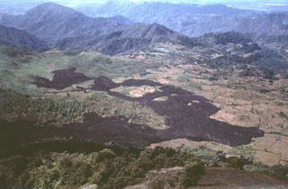 In February 1972 a lava flow from vents at the base of MacKenney cone at Pacaya descended the western flanks and covered farmlands on the caldera floor. The flow was diverted around topographic irregularities, forming several large kipukas. Lava effusion began on 2 February and lasted until the 27th. This December 1972 photo was taken from the summit of MacKenney cone with a village to the upper right
 Photo by Bill Rose, 1972 (Michigan Technological University).
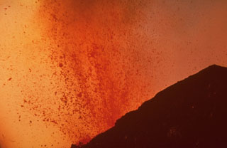 Molten lava bombs ejected from MacKenney crater at Pacaya fill most of this 1968 photo. Strombolian eruptions began at MacKenney crater in 1965 and continued for several decades.
Photo by William Melson, 1968 (Smithsonian Institution).
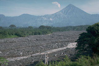 Lahar deposits produced by the remobilization of Santiaguito lava dome collapse deposits. The dome is visible below the steam plume to the left of Guatemala's Santa María volcano. Lahars have dramatic effects on downstream drainages, as seen in this December 1988 photo that shows the Río Tambor to the SW, filled bank-to-bank with debris. Bridges such as the one in the foreground have frequently been destroyed during rainy-season lahars, which have traveled 35 km or more from the volcano.
Photo by Lee Siebert, 1988 (Smithsonian Institution).
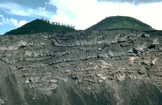 A sequence of thin lava flows forms the upper part of the Pacaya NE crater wall. These basaltic lava flows were erupted during the final stages of an ancestral Pacaya edifice, which collapsed sometime between about 1,550 and 600 years ago to form a large horseshoe-shaped crater. The upper approximately 50 m of the wall is seen in this view with Cerro Grande, an older dome of Pacaya, forming the rounded peak to the right with the Cerro Chiquito cone to the left.
Photo by Lee Siebert, 1988 (Smithsonian Institution).
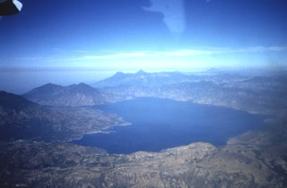 A panoramic view to the west across Lake Atitlán shows the flanks of Tolimán volcano extending to the lakeshore on the left, San Pedro volcano at the SW end of the lake, and the two peaks of Santo Tomás (left) and Santa María (right) on the center horizon. Tajumulco volcano appears in the distance at the upper right. Lake Atitlán occupies the northern half of the youngest Atitlán caldera, which formed during the eruption of the Los Chocoyos Ash about 84,000 years ago.
Photo by Bill Rose, 1972 (Michigan Technological University).
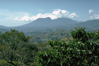 Tecuamburro, seen here from the north, is a small lava dome complex of mostly Pleistocene age. The smoother left flank consists of younger lava domes that were constructed during the late Pleistocene or early Holocene within a horseshoe-shaped, east-facing scarp. The scar resulted from structural failure of the older Miraflores edifice (right).
Photo by Lee Siebert, 1988 (Smithsonian Institution).
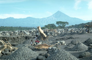 The debris from the Santiaguito lava dome (visible below and to the left of the summit of Santa María) severely impacts downslope river drainages. Frequent rainy season lahars descend the Río Samalá, seen here just south of the Pacific coastal highway. Major lahars on 28 August 1993 (three months prior to this photo) covered 200 m of the highway and filled the river channel to within 50 cm of the highway bridge. A small-scale construction aggregate operation can be seen in the foreground.
Photo by Lee Siebert, 1993 (Smithsonian Institution).
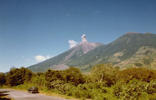 A small ash plume rises at Fuego on 10 October 1977, seen here from the NE along the road to Alotenango, about 10 km away. Intermittent minor ash took place from 11 September 1977 to 8 August 1979, sometimes accompanied by pyroclastic flows and lava flows. Explosions were often closely spaced.
 Photo by Paulino Alquijay, 1977 (courtesy of Pete Newton).
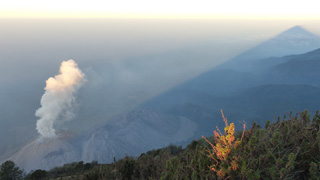 This February 2017 view of El Caliente of the Santiaguito lava dome complex is from the Santa Maria summit (producing the shadow to the right). The other Santiaguito domes visible from left to right (approximately NE-SW) are El Caliente, La Mitad, El Monje, and El Brujo. El Caliente is degassing through its characteristic ring-shaped fracture network.
Photo by Ailsa Naismith, 2017.
 Volcanologist Bill Rose (right) and colleagues interview Don Patricio Parouche (center), an eyewitness of the catastrophic 1929 Santiaguito eruption. This eruption was the largest during the more than 75 years of lava dome growth, and produced pyroclastic flows that extended 10 km, nearly to the location of the village of El Palmar. At least 5,000 people were killed during this eruption.
Photo courtesy Bill Rose, 1988 (Michigan Technological University).
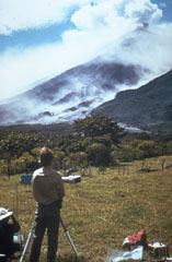 Scientists use a COSPEC (Correlation Spectrometer) instrument to measure the sulfur dioxide (SO2) content of a volcanic plume from Fuego volcano in Guatemala. Measuring the amount of SO2 and other gases in volcanic plumes are useful tools for eruption monitoring. This photo of Dick Stoiber (left) and Gary Malone (standing) was taken by Tom Crafford from Finca Capetillo NE of Fuego during its October 1974 eruption.
Photo by Tom Crafford, 1974 (Dartmouth College, courtesy of Dick Stoiber).
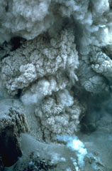 This closeup view of an ash plume rising from the El Brujo lava dome was taken on 13 November 1967. Explosions such as these are common at the growing lava dome, sometimes occurring within minutes of each other. The crater wall is visible at the lower left.
Photo by Charles Pineo, 1967 (Dartmouth College, courtesy of Dick Stoiber).
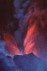 Vigorous lava fountaining occurred during a major eruptive episode the afternoon of 16 January 2000, initially reaching heights of 800 m then diminishing to 300 m. Fallout from the fountains fed near-constant avalanches and lava flows that traveled to the SW and N. Typical Strombolian activity resumed around 2030 that day. More or less continuous activity had resumed at Pacaya in January 1990 after 9-month-long quiescence.
Photo by Gene West, 2000.
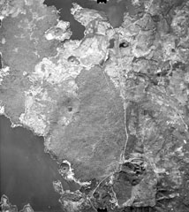 Young lava flows from Volcán de San Diego (left center) extend into Lake Güija (lower left). The prominent cinder cone on the lake shore directly south of Volcán de San Diego is Cerro el Tule. Young basaltic lava flows from other vents of the San Diego volcanic field in western El Salvador, such as Cerro la Vega de la Cana and Loma Iguana (upper left), extend into both Lake Güija and Laguna de Metapán at the top of the photo. The cinder cone north of Volcán de San Diego (surrounded by older lava flows) is Cerro Masatepeque.
Aerial photo by Instituto Geográfico Nacional El Salvador, 1977.
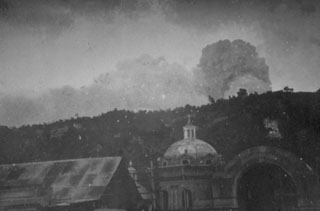 One of the largest eruptions of the 20th century took place 24-25 October 1902 from Santa María. During the Plinian phase explosions were heard in Costa Rica and ash plume heights of 27-29 km were recorded. Ashfall was primarily dispersed NW and eventually reached Mexico City; during the day on 25 October much of the Pacific coastal plain was in darkness. This photo shows an eruption plume on an unknown date from the city of Quetzaltenango, 10 km north of the volcano.
Photo by Anonymous, 1902 (courtesy of Dick Stoiber, Dartmouth College).
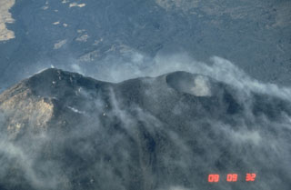 MacKenney crater (right), constructed NW of an older cone at the left, has been the source of most of Pacaya's historical eruptions. Frequent Strombolian eruptions repeatedly build up the cone after it is partially destroyed by intermittent larger explosions. An extensive lava flow field produced from MacKenney cone since 1965 is in the background of this 25 January 1987 view from the NE.
Photo by Norm Banks, 1987 (U.S. Geological Survey).
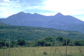 The Pacaya volcanic complex is seen here from the north. The rounded Cerro Grande lava dome forms the high point to the left. The peak to the right is the historically active cone of Pacaya. It was constructed within an arcuate crater whose rim forms the flat ridge on either side of the cone. This September 1962 photo was taken prior to a long-term eruption beginning in 1965 from a new vent on the western flank. Frequent eruptions built MacKenney cone, which grew to the height of the previous cone.
Photo by Dick Stoiber, 1962 (Dartmouth College).
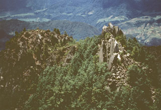 Lava spines are seen here along the summit ridge of Cerro Quemado, the youngest of a series of lava domes erupted along the margins of Almolonga volcano. The early stages of the Cerro Quemado complex eruptions produced a sequence of lava flows and domes erupted from at least eight vents. During the later stages about 1,150 years ago the summit dome of Cerro Quemado was emplaced following failure of the summit area. An eruption took place from an E-flank vent in 1818.
Photo by Bill Rose, 1972 (Michigan Technological University).
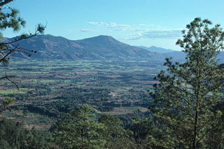 Jumaytepeque, on the center horizon, was constructed near the SE rim of a caldera, and is possibly Holocene. The volcano on the far horizon is Ixhuatán.
Photo by Jim Reynolds, 1975 (Brevard College).
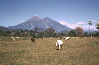 Fuego and Acatenango volcanoes tower more than 3.5 km above farmlands of the Pacific coastal plain. Edifice failure of these volcanoes has occurred in the direction of the coastal plain, producing major debris avalanches that reached as far as 50 km away.
Photo by Bill Rose, 1970 (Michigan Technological University).
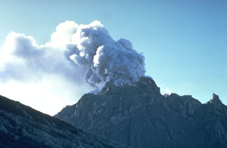 An ash plume rises above the Caliente vent in February 1968. Lava spines protrude from the easternmost vent of the Santiaguito lava dome. The flank of the Santa María edifice appears to the left in this view from the north.
Photo by Dick Stoiber, 1968 (Dartmouth College).
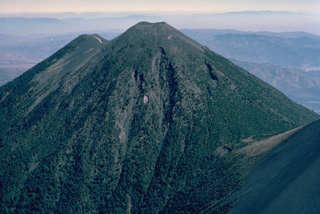 Acatenango, forming a twin volcano with Volcán Fuego to the south, itself has two summits. Activity at Yepocapa (left), the northern summit of Acatenango, ended about 20,000 years ago, after which the southern and highest cone, Pico Mayor, was constructed. The first well-documented eruptions of Acatenango took place from 1924 to 1927, although earlier historical eruptions may have occurred. This aerial view is from the SW.
Copyrighted photo by Katia and Maurice Krafft, 1983.
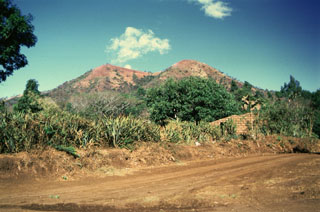 Loma Los Siete Cerros (Peak of the Seven Hills) is part of the Volcán Chingo volcanic field. This complex of overlapping scoria cones on the Salvadoran side is seen here from the east and is one of many flank vents. Among the youngest vents are those that produced lava flows on the NW side in Guatemala. Other young flows erupted from an intermittent chain of cones extending N-S on both side of the summit.
Photo by Giuseppina Kysar, 1999 (Smithsonian Institution).
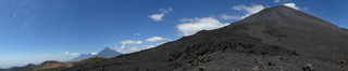 This February 2018 panorama shows the relative positions of several eastern Guatemalan volcanoes. From left to right are Fuego, Acatenango, Agua, and Pacaya.
Photo by Ailsa Naismith, 2018.
 Strombolian eruptions at a spatter cone in Pacaya’s MacKenney crater. Lava flows through a notch in the crater and descends the northern flank. The date of the photo is uncertain, but may have been around 1967.
Photo by Alfredo MacKenney (courtesy of Bill Rose, Michigan Technological University).
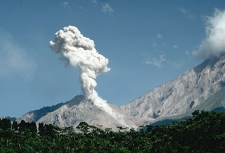 An ash plume rises above Caliente in the Santiaguito lava dome complex in November 1993 as a small pyroclastic flow descends its eastern flank. The headwall of the 1902 crater on the Santa María SW flank is to the right. The lava dome complex began growing in 1922 from the Caliente vent at the base of the 1902 explosion crater. Caliente has been frequently active since the early 1970s.
Photo by Lee Siebert, 1993 (Smithsonian Institution).
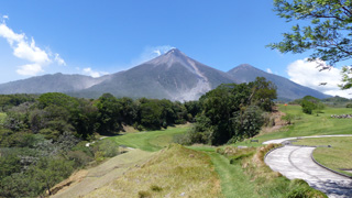 Fuego (left) and Acatenango (right, behind) are seen here from La Reunion Golf Resort and Residences below the SE flank in March 2017. Barranca Las Lajas is the ravine from the summit down the flank, containing eruption deposits from the frequent activity. Weak degassing from the summit is producing a faint plume dispersing towards the SW.
Photo by Ailsa Naismith, 2017.
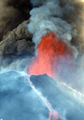 A lava fountain and ash plumes erupt above MacKenney crater at Pacaya during a major eruptive episode on 16 January 2000. A lava flow is also descending the northern flank of the cone. After a quiescent period of nine months, eruptive activity had been more or less continuous at Pacaya since January 1990. Activity has consisted of frequent moderate eruptions that constructed the summit cone, punctuated by occasional larger explosions such as this one that enlarge the crater and reduce the height of the cone.
Photo by Gene West, 2000.
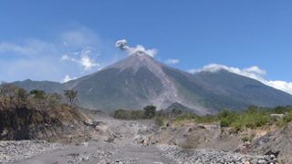 An ash plume from a small explosion at Fuego is being dispersed towards the E by the wind in this 8 March 2020 photo taken from the new Las Lajas bridge. A new bridge was constructed after the previous one was destroyed by the 3 June 2018 eruption that devastated nearby areas. The ravine in the foreground is Barranca Las Lajas, which channeled the majority of pyroclastic flow material produced in the 3 June eruption. Deposits from these pyroclastic flows are visible in the foreground, with dead trees and scorched vegetation on the left margin of the ravine showing some of the impacts of the hot flow.
Photo by Ailsa Naismith, 2020.
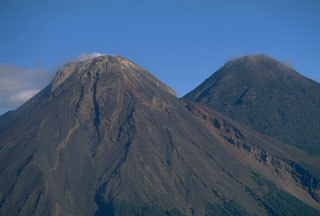 Fuego and Acatenango are seen here from the SE and are result of eruptions along a N-S line that moved progressively towards the south. The gully on the righthand side of Fuego is the rim of a scarp produced by the collapse of ancestral Meseta volcano, which preceded the growth of the modern Fuego edifice.
Copyrighted photo by Stephen O'Meara, 1994.
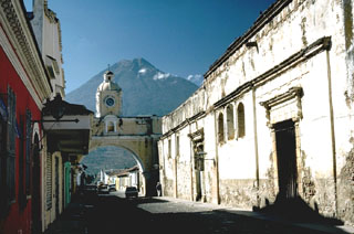 Volcán de Agua behind the historical colonial city of Antigua Guatemala and is one of three large volcanoes surrounding the town. The capital city of Guatemala was moved here following a catastrophic mudflow from Agua in 1541 that destroyed the former capital city, now known as Ciudad Vieja.
Photo by Lee Siebert, 1988 (Smithsonian Institution).
 The Santa María western flank of is seen here at sunset. The light-colored area to the upper right is the upper headwall of the 1902 explosion crater across the SW flank. Pumice deposits from the 1902 eruption are visible across the flanks, exceeding 15 m in thickness.
Photo by Bill Rose, 1970 (Michigan Technological University).
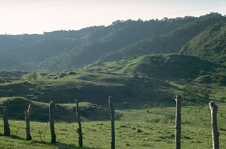 The hilly terrain in the foreground is part of a debris avalanche deposit that extends 25 km from the summit of Pacaya to the Pacific coastal plain. Part of the avalanche traveled more than 100 m up the side of the ridge in the background before coming to rest on the valley floor. The avalanche was accompanied by a pyroclastic surge whose deposits overlie the proximal 10 km.
 Photo by Lee Siebert, 1988 (Smithsonian Institution).
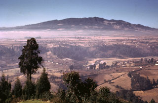 The NE flanks of the broad Siete Orejas massif rise above farmlands on the banks of the Sigüilá river. A large caldera is breached to the south, on the opposite side of the volcano. The volcano overlooks Quetzaltenango, Guatemala's second largest city, which is out of view to the left. The broad irregular summit profile gives the volcano its name, which means "Seven Ears." The latest eruption of Siete Orejas is stratigraphically constrained to have occurred between about 126,000 and 85,000 years ago.
 Photo by Bill Rose, 1974 (Michigan Technological University).
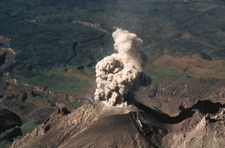 An ash plume rises above Caliente vent at Santiaguito in February 1988. Eruptions at this time took place at intervals of 1 or 2 per hour and consisted of brief 1-2 minute ash emissions that reached altitudes of about 4 km (slightly above the elevation of the summit of Santa María, from where the photo was taken). Light ashfall from these small explosions affected areas to about 6 km from the vent.
Photo by Jon Fink, Arizona State University, 1988 (courtesy of Bill Rose, Michigan Technological University).
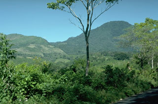 The low ridge on the left-hand horizon is the southern rim of a large horseshoe-shaped crater left by collapse of Miraflores, an ancestral edifice of the Tecuamburro volcanic complex. Miraflores formed about 100,000 years ago and collapsed sometime prior to 38,000 years ago. The vegetated peak to the right is part of the Tecuamburro lava dome complex, which formed within the scarp.
Photo by Lee Siebert, 1988 (Smithsonian Institution).
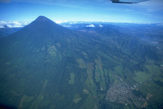 Volcán de Agua is seen here in an aerial view from the SE, with the town of Palín to the lower right along the highway between Guatemala City (just out of view to the right) and Escuintla.
 Copyrighted photo by Stephen O'Meara, 1994.
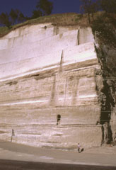 Thick sequences of tephra from Amatitlán caldera are exposed in roadcuts in the Guatemala City area, note INSIVUMEH geologist Otoniel Matías for scale at the lower right. This exposure is located south of the capital city, along the road to Palin. Major explosive eruptions from Amatitlán caldera have been dated to between about 300,000 to less than 23,000 years ago. The northern caldera rim is buried by thick pyroclastic deposits and underlies portions of Guatemala City.
 Photo by Lee Siebert, 1999 (Smithsonian Institution).
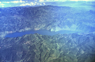 The figure-8-shaped Ayarza caldera appears elongated in this aerial oblique view from the SW. The double caldera was formed during two major rhyolitic eruptions about 27,000 and 23,100 years ago. These were among the youngest silicic eruptions in northern Central America. The larger western caldera (left) has a maximum depth of 240 m, and the eastern caldera is 140 m deep. Caldera walls rise an additional 300-600 m above the surface of Laguna de Ayarza.
Photo by Carlos Pullinger, 1996 (Servicio Nacional de Estudios Territoriales, El Salvador).
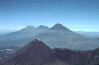 This view from the east shows four major volcanoes located within 45 km of Guatemala City. In the foreground is Pacaya, which has been in frequent eruption since 1965. The modern cone (left) partially overlaps the rim of a large caldera. The large volcano in the midground horizon is Volcán de Agua. In the background is Acatenango (right) and Fuego (left).
 Photo by Bill Rose, 1991 (Michigan Technological University).
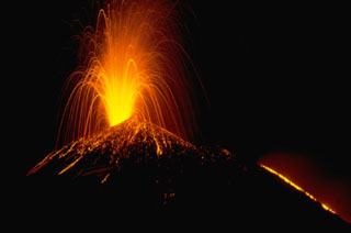 A Strombolian eruption at Pacaya volcano in Guatemala, November 1988. This time exposure shows the incandescent parabolic arcs of individual volcanic bombs explosively ejected from the vent. Larger bombs remain incandescent after they hit the surface of the cone and roll down its flanks. The orange line at the lower right is a lava flow extruding from a fissure on the upper NW flank of the MacKenney cone.
Photo by Lee Siebert, 1988 (Smithsonian Institution).
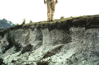 Deposits of the 1902 Plinian eruption are exposed in a 1-m-thick outcrop 3.2 km S of Llano del Pinal, the saddle between Santa María and Siete Orejas volcanoes. The pumice is overlain by about 15 cm of finer-grained darker-colored ash. Most of the outcrop consists of light-colored dacite pumice fragments. Pumice fall was reported in Tapachula across the Mexican border, and ashfall was reported in Mexico City.
Photo by Bill Rose, 1967 (Michigan Technological University).
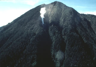 An aerial view of the NE flank of Tacaná volcano on 25 June 1986 shows a steam plume rising above a new vent. Minor phreatic eruptions, the first since 1949, took place in February, May, and June 1986. Following a seismic swarm beginning the previous day, a moderate phreatic explosion around noon on 8 May created a new 10-m-wide vent and ejected a small amount of fine ash. Vegetation was damaged over an area of 200 x 100 m.
Photo by Bill Rose, 1986 (Michigan Technological University).
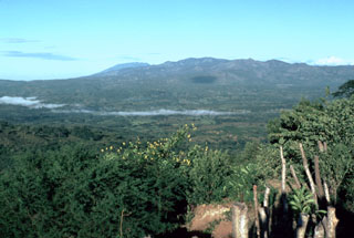 Morning fog drapes the valley of the Río Margarita, with Ixhuatán volcano in the background. The broad summit of Tecuamburro volcano is visible to the west behind Ixhuatán on the horizon left of center. Los Ochiotes complex in the center of Ixhuatán volcano is the youngest part of the volcano and consists of a group of dacitic lava domes that fills a horseshoe-shaped depression open to the SE.
 Photo by Lee Siebert, 1988 (Smithsonian Institution).
 The upper SE flanks of Fuego (left) and Acatenango (right) are seen here, with their summits that lie only 3 km apart along a N-S line. The modern Fuego edifice was constructed within a scarp left by collapse of the ancestral Mesata, whose flank appears to the right of the summit towards the saddle between the two.
 Photo by Lee Siebert, 1988 (Smithsonian Institution).
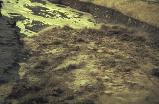 The advancing front of a lahar travels down the Río Nimá Segundo below the Santiaguito lava dome complex on 14 August 1989. Sediment yields in drainages below the Santa Maria’s active domes are extremely high, and rainy season lahars frequently impact areas downstream.
Photo by Jeff Marso, 1989 (Michigan Technological University).
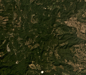 The Pleistocene Piedra Grande is the topographically indistinct area in the center of this December 2019 Planet Labs satellite image monthly mosaic (N is at the top; image is approximately 14 km across). The complex consists of heavily eroded, faulted cones, and has undergone extensive hydrothermal alteration.
Satellite image courtesy of Planet Labs Inc., 2019 (https://www.planet.com/).
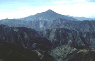 Tajumulco is seen here from the NNW. It rises above deeply eroded valleys within plutonic and Tertiary volcanic rocks. Prior to this 1986 photo there had been several unconfirmed reports of eruptions.
Photo by Bill Rose, 1986 (Michigan Technological University).
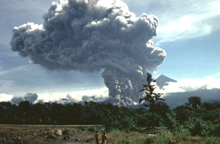 A large pyroclastic flow travels down the flank of the Santiaguito lava dome on 19 July 1989. The pyroclastic flow and ash plume are seen here from just west of El Palmar (10 km S of the dome) about 5 minutes after the start of the explosion. The Santa María summit is visible to the right of the plume, which rose to 4 km above the vent. The pyroclastic flow traveled 5 km down the Río Nimá and was one of the larger events since the major 1929-34 activity.
Photo by Mike Conway, 1989 (Michigan Technological University).
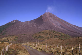 Lava flows were erupted in late 1998, seen across the upper left-hand flank of the degassing MacKenney cone at Pacaya in February 1999. They originated from vents at the summit and upper flanks of the cone and descended into the caldera before being deflected by the caldera wall to the west. The hill on the left horizon is Cerro Chino, a scoria cone constructed on the NW crater rim. Strong explosive eruptions in 1998 created a notch in the summit of MacKenney cone and the deep gully that extends diagonally down to the right.
Photo by Lee Siebert, 1999 (Smithsonian Institution).
 Massive airfall pumice deposits blanket the countryside around Siete Orejas volcano. The coarse white rhyodacitic pumice creates the impression of snowfall over broad areas, and on the volcano itself the mantle is so thick that underlying lavas are rarely exposed. Eruption of the airfall pumice was followed by the production of massive pumiceous pyroclastic flows that filled the valley of Quetzaltenango to depths up to about 75 m.
Photo by Bill Rose, 1981 (Michigan Technological University).
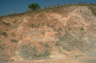 This roadcut provides a spectacular section through a debris avalanche deposit hummock of the Fuego-Acatenango complex in Guatemala. The pronounced color mottling is a common texture of debris-avalanche deposits and distinguishes them from deposits produced by other volcanic processes such as mudflows or pyroclastic flows. This texture results from the transport of coherent chunks of the volcano over long distances with only partial disaggregation. Individual lava flow blocks and pyroclastic units can be traced across small offsetting faults.
Photo by Lee Siebert, 1988 (Smithsonian Institution).
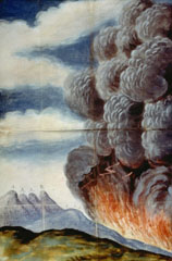 One of the largest historical eruptions of Pacaya, which occurred in 1775, is illustrated in this contemporary painting. The explosive eruption began on 1 July 1775 when several vents opened on the SW flank of Cerro Chino. A lava flow traveled to the south, eventually reaching 1,000 m elevation. The vents migrated towards the summit of Cerro Chino; one reference refers to activity at the summit 22 days into the eruption. Ashfall from this eruption was reported up to 200 km away.
Anonymous painting (courtesy of Archivo Real Academia de la Historia, Madrid).
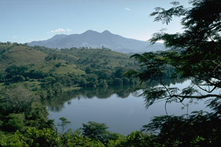 Moyuta is the easternmost of a chain of large volcanoes extending along the volcanic front of Guatemala. The summit contains a cluster of forested lava domes. It is viewed here from a small lake to its SW at the edge of the Pacific coastal plain.
 Photo by Lee Siebert, 1988 (Smithsonian Institution).
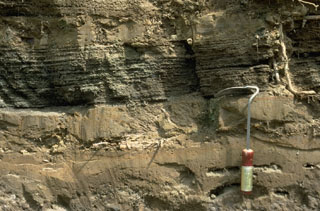 These fine-grained ash layers and coarser laminated scoria-bearing layers were deposited by pyroclastic surges following collapse of the summit of Pacaya. This surge deposit overlies the avalanche deposit and the topography in a 90 degree arc as far as 10 km SW of the summit.
 Photo by Lee Siebert, 1988 (Smithsonian Institution).
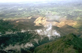 A lava flow from El Brujo, the westernmost of the Santiaguito vents, advances down a SW-flank valley in November 1973. An eruption phase in 1972-75 produced six lava flow units and a small lava dome. It was unusual in that extrusion took place simultaneously from two vents at the western and eastern ends of Santiaguito.
Photo by William Melson, 1973 (Smithsonian Institution).
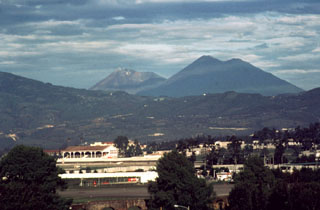 Acatenango (right) is seen here with Fuego at the center in 1986. Volcán Acatenango was constructed during three eruptive periods post-dating the roughly 84,000-year-old Los Chocoyos Ash from Atitlán caldera. The eruptive period of Yepocapa, the northern peak of Acatenango, ceased about 20,000 years ago. The eruption of the southern and highest cone, Pico Mayor began at that time.
Photo by Bill Rose, 1986 (Michigan Technological University).
 An ash plume rises above the Santiaguito lava dome complex in June 1976 nearly to the height of Santa María's summit. The dome complex was constructed within a large explosion crater that formed in the SW flank of during the major 1902 explosive eruption. The crater, seen in profile here, extends from just below the summit to 2.2 km elevation, below the bottom of the photo.
Photo by Bill Rose, 1976 (Michigan Technological University).
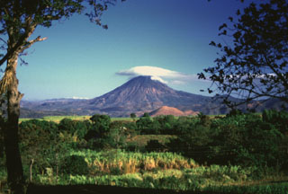 Volcán Chingo is located on the Guatemala/El Salvador border, seen here from the SE on the Salvador side of the border. The light-brown hill below is Cerro Laguneta. Other flank vents are located on the NE side and several recent lava flows are to the west and north.
Photo by Giuseppina Kysar, 1999 (Smithsonian Institution).
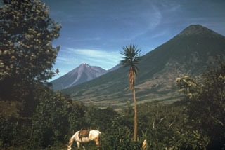 Volcán de Agua, seen here from the NE, is the most prominent volcano visible from Guatemala City. Fuego volcano in the background has been much more active historically.
 Photo by Mike Carr, 1967 (Rutgers University).
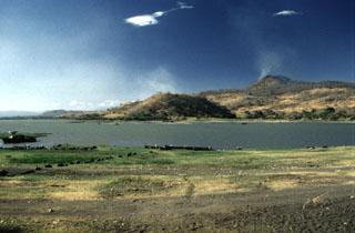 An extensive volcanic field of scoria cones and lava flows near Lake Güija is named after its largest feature, Volcán de San Diego (upper right). A large lava flow from the San Diego scoria cone dammed the drainage and was responsible for the formation of 12-km-long Lake Güija, which lies mostly in El Salvador and extends across the border into Guatemala. Cerro el Tule scoria cone in the center of the photo is near the eastern shore of the lake.
Photo by Giuseppina Kysar, 1999 (Smithsonian Institution).
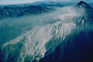 Two decades after a powerful explosive eruption in 1902 blasted a 1-km-wide crater through the SW flank of Santa María volcano, a lava dome began growing at the base of the crater. Santiaguito lava dome, forming the elongated unvegetated ridge at the center of the photo, has been continually active since 1922. Frequent explosive eruptions accompany episodic periods of more rapid lava dome growth and effusion of lava flows down the flanks of the dome. The summit of Santiaguito is about 1300 m below that of Santa María at the upper right.
Copyrighted photo by Katia and Maurice Krafft, 1983.
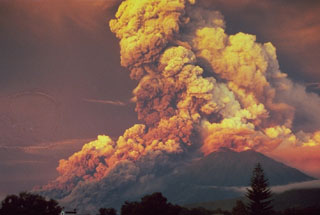 A powerful eruption at Fuego produced this ash plume at sunrise in October 1974. This view from Antigua Guatemala to the NE shows major pyroclastic flows moving down the eastern flank. Pyroclastic flows traveled 7 km but caused no fatalities. The 1974 eruption, the largest at Fuego since 1932, began with mild eruptions and small pyroclastic flows on 10 October. The eruption intensified on 14 October, with major Vulcanian eruptions occurring on that day, as well as 17-18, 19-20, and 23 October.
Photo by William Buell, 1974.
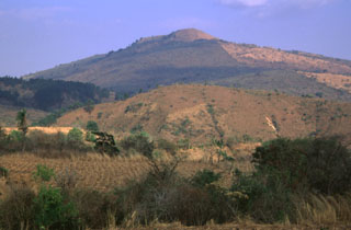 Volcán Flores rises above foothills on its western flank. The volcano is one of the largest of a group of small volcanoes behind the volcanic front in SE Guatemala and rises about 600 m above its base.
Photo by Rick Wunderman, 1999 (Smithsonian Institution).
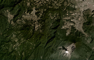 The large scarp of Siete Orejas is down the center of this November 2020 Planet Labs satellite image monthly mosaic (N is at the top; this image is approximately 21 km across). Seven peaks surround the scarp, which likely formed during flank collapse towards the south. The city of Quetzaltenango is NE and Santa María volcano is SE, with a gas plume rising from the Caliente Dome. The Volcan Chicabal is on the SW flank, containing Chicabal Lake.
Satellite image courtesy of Planet Labs Inc., 2020 (https://www.planet.com/).
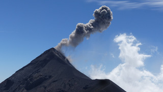 This 18 February 2020 photo shows an example of a typical Vulcanian explosion at Fuego The view is from the lookout area on Volcán Acatenango, about 2 km N, with the ash plume dispersing to the W.
Photo by Ailsa Naismith, 2020.
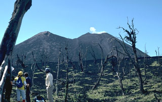 Near-continuous mild Strombolian explosions, such as the one producing the small plume above MacKenney crater at Pacaya to the right, have been punctuated by periodic larger explosions that eject incandescent bombs and large blocks. These trees on the Meseta (foreground) were stripped of vegetation by the larger explosions. The MacKenney cone to the right has been growing since 1965 on the flank of the older cone to the left.
Photo by Lee Siebert, 1988 (Smithsonian Institution).
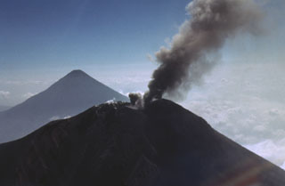 A small ash plume from the summit of Fuego on 27 February 1978 is deflected to the south as a second plume rises from another vent immediately to the left. Volcán de Agua is in the distance. Fuego erupted intermittently from September 1977 to August 1979.
Photo by Bill Rose, 1978 (Michigan Technological University).
This is a compilation of Guatemala volcano information sources, such as official monitoring or other government agencies.
| Civil Protection Agencies | |
|---|---|
| Coordinadora Nacional para la Reducción de Desastres (CONRED) | |
| - CONRED Report Archive | |
| Volcanic Ash Advisory Center | |
|---|---|
| Washington Volcanic Ash Advisory Center (VAAC) | |
| - Washington VAAC Archive | |
| - Washington VAAC Notices | |